
Haz una donación
Equípate para tu próxima aventura:
Como asociado de Amazon, este sitio gana comisiones por las compras que califican, sin ningún costo adicional para usted.
Mapa topográfico Walnut Creek
Haga clic en el mapa para ver la altitud.
Haz una donación
Equípate para tu próxima aventura:
Como asociado de Amazon, este sitio gana comisiones por las compras que califican, sin ningún costo adicional para usted.
Walnut Creek
Walnut Creek's warm summer Mediterranean climate (Köppen climate classification Csb) is typical of California's interior valleys. In summer, high pressure results in almost unbroken sunshine and virtually no precipitation. Days start out cool but quickly warm up, with high temperatures normally in the 80s Fahrenheit (27 to 32 °C). Temperatures of 100 °F (38 °C) or hotter occur numerous times during heatwaves, however. In the winter, the jet stream moves far enough south so that Pacific storms can reach Walnut Creek, bringing much-needed rain – average annual rainfall approximates 20 inches (510 mm), with slight variations occurring in microclimates based on elevation and topography. During particularly cold storms, snow falls on the peak of nearby Mount Diablo, but snow in the valley floor is very rare. There are numerous clear, mild days in winter, often with morning frost. The climate allows for the successful cultivation of many plants and crops, being warm enough for citrus yet cold enough for apples. The Ruth Bancroft Garden is a renowned botanical garden that showcases the diversity of plants that can be successfully grown.
Haz una donación
Equípate para tu próxima aventura:
Como asociado de Amazon, este sitio gana comisiones por las compras que califican, sin ningún costo adicional para usted.
Acerca de este mapa
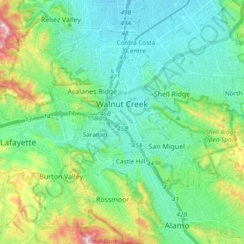
Nombre: Mapa topográfico Walnut Creek, altitud, relieve.
Altitud media: 119 m
Altitud mínima: 16 m
Altitud máxima: 441 m
Haz una donación
Equípate para tu próxima aventura:
Como asociado de Amazon, este sitio gana comisiones por las compras que califican, sin ningún costo adicional para usted.
Otros mapas topográficos
Haga clic en un mapa para ver su topografía, su altitud y su relieve.
Contra Costa Centre
United States > California > Contra Costa County
Contra Costa Centre is an unincorporated community and census-designated place in Contra Costa County, California. Contra Costa Centre sits at an elevation of 92 feet (28 m). The 2010 United States census reported Contra Costa Centre's population was 5,364, while the 2020 census figure was 6,808. Contra Costa…
Altitud media: 36 m
Haz una donación
Equípate para tu próxima aventura:
Como asociado de Amazon, este sitio gana comisiones por las compras que califican, sin ningún costo adicional para usted.
Haz una donación
Equípate para tu próxima aventura:
Como asociado de Amazon, este sitio gana comisiones por las compras que califican, sin ningún costo adicional para usted.
Haz una donación
Equípate para tu próxima aventura:
Como asociado de Amazon, este sitio gana comisiones por las compras que califican, sin ningún costo adicional para usted.
Saranap
United States > California > Contra Costa County
Saranap (until 1913, Dewing Park) is a residential census-designated place (CDP) within central Contra Costa County, California. Lying at an elevation of 180 feet (55 m), it is bounded on the south and east by portions of Walnut Creek (including the gated senior residential development Rossmoor) and on the…
Altitud media: 92 m
Haz una donación
Equípate para tu próxima aventura:
Como asociado de Amazon, este sitio gana comisiones por las compras que califican, sin ningún costo adicional para usted.
Haz una donación
Equípate para tu próxima aventura:
Como asociado de Amazon, este sitio gana comisiones por las compras que califican, sin ningún costo adicional para usted.
Haz una donación
Equípate para tu próxima aventura:
Como asociado de Amazon, este sitio gana comisiones por las compras que califican, sin ningún costo adicional para usted.
Haz una donación
Equípate para tu próxima aventura:
Como asociado de Amazon, este sitio gana comisiones por las compras que califican, sin ningún costo adicional para usted.
Crolona Heights
United States > California > Contra Costa County > Crockett > Crolona Heights
Altitud media: 61 m
Haz una donación
Equípate para tu próxima aventura:
Como asociado de Amazon, este sitio gana comisiones por las compras que califican, sin ningún costo adicional para usted.