Geolocalizar

Mapa topográfico Congleton

Haga clic en el mapa para ver la altitud.

Acerca de este mapa

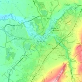
Nombre: Mapa topográfico Congleton, altitud, relieve.

Lugar: Congleton, Cheshire East, England, United Kingdom (53.13596 -2.25081 53.19023 -2.14072)

Altitud media: 119 m

Altitud mínima: 59 m

Altitud máxima: 244 m

Otros mapas topográficos

Haga clic en un mapa para ver su topografía, su altitud y su relieve.

Poynton

United Kingdom > England > Cheshire East

Altitud media: 130 m

Oakgrove

United Kingdom > England > Cheshire East

Altitud media: 200 m

Lyme Park

United Kingdom > England > Cheshire East > Disley

Altitud media: 260 m

Wilmslow

United Kingdom > England > Cheshire East

Altitud media: 84 m

Weston

United Kingdom > England > Cheshire East

Altitud media: 64 m

Calveley

United Kingdom > England > Cheshire East

Altitud media: 58 m

Mow Cop

United Kingdom > England > Cheshire East

Altitud media: 220 m

Allgreave

United Kingdom > England > Cheshire East

Altitud media: 317 m

Langley

United Kingdom > England > Cheshire East

Altitud media: 244 m

Checkley

United Kingdom > England > Cheshire East

Altitud media: 85 m

Marbury

United Kingdom > England > Cheshire East

Altitud media: 92 m

Shining Tor

United Kingdom > England > Cheshire East

Shining Tor is the highest hill in Cheshire, England. The summit has an elevation of 559 m (1,834 ft) above sea level. It is in the Peak District, between the towns of Macclesfield in Cheshire and Buxton in Derbyshire, and is on the administrative boundary between Derbyshire and Cheshire East. The hill is at…

Altitud media: 440 m

Acton

United Kingdom > England > Cheshire East

Altitud media: 53 m

Ginclough

United Kingdom > England > Cheshire East

Altitud media: 287 m

Hough

United Kingdom > England > Cheshire East

Altitud media: 62 m

Equípate para tu próxima aventura:

👟Zapatillas de Trail Running Hombre - Calzado ligero y con tracción para correr por senderos
🪵Hornillos de camping - Cocina portátil para exterior
📸Trípodes Ligeros para Fotografía - Estabilidad para tus fotos de paisajes topográficos
🧖Ponchos de Lluvia - Protección rápida que cubre también la mochila
🛡️Fundas Impermeables para Mochila - Mantén tu equipo y mapas secos bajo cualquier tormenta

Como asociado de Amazon, este sitio gana comisiones por las compras que califican, sin ningún costo adicional para usted.