
Haz una donación
Equípate para tu próxima aventura:
Como asociado de Amazon, este sitio gana comisiones por las compras que califican, sin ningún costo adicional para usted.
Mapa topográfico Lentini
Haga clic en el mapa para ver la altitud.
Haz una donación
Equípate para tu próxima aventura:
Como asociado de Amazon, este sitio gana comisiones por las compras que califican, sin ningún costo adicional para usted.
Lentini
Lentini is a municipality of 215.84 km² located 52 km northwest of the provincial capital, Syracuse. It is situated at an elevation of 53 meters above sea level on the first hill slopes at the southern edge of the Plain of Catania.
Haz una donación
Equípate para tu próxima aventura:
Como asociado de Amazon, este sitio gana comisiones por las compras que califican, sin ningún costo adicional para usted.
Acerca de este mapa
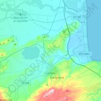
Nombre: Mapa topográfico Lentini, altitud, relieve.
Lugar: Lentini, Siracusa, Sicily, 96016, Italy (37.24796 14.77834 37.41288 15.03319)
Altitud media: 69 m
Altitud mínima: -2 m
Altitud máxima: 480 m
Haz una donación
Equípate para tu próxima aventura:
Como asociado de Amazon, este sitio gana comisiones por las compras que califican, sin ningún costo adicional para usted.
Otros mapas topográficos
Haga clic en un mapa para ver su topografía, su altitud y su relieve.