
Haz una donación
Equípate para tu próxima aventura:
Como asociado de Amazon, este sitio gana comisiones por las compras que califican, sin ningún costo adicional para usted.
Mapa topográfico Burnet
Haga clic en el mapa para ver la altitud.
Haz una donación
Equípate para tu próxima aventura:
Como asociado de Amazon, este sitio gana comisiones por las compras que califican, sin ningún costo adicional para usted.
Acerca de este mapa
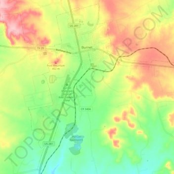
Nombre: Mapa topográfico Burnet, altitud, relieve.
Lugar: Burnet, Burnet County, Texas, 78611, United States (30.69130 -98.27983 30.78552 -98.16564)
Altitud media: 404 m
Altitud mínima: 334 m
Altitud máxima: 491 m
Haz una donación
Equípate para tu próxima aventura:
Como asociado de Amazon, este sitio gana comisiones por las compras que califican, sin ningún costo adicional para usted.
Otros mapas topográficos
Haga clic en un mapa para ver su topografía, su altitud y su relieve.
Inks Lake State Park
United States > Texas > Burnet County > Burnet
Conservation Pool Elevation usually stays around 888.22 ft. msl; however, this lake does fluctuate about 1 foot annually. Inks lake water clarity can be seen as clear to slightly stained mostly throughout the year. It tends to have higher turbidity during the rainy season due to excessive amounts of runoff.
Altitud media: 294 m
Haz una donación
Equípate para tu próxima aventura:
Como asociado de Amazon, este sitio gana comisiones por las compras que califican, sin ningún costo adicional para usted.
Briggs
United States > Texas > Burnet County
Briggs lies along U.S. Route 183 and FM 2657, northeast of Burnet. Its elevation is 1,102 feet (336 m), and it is located at 30°53′23″N 97°55′30″W / 30.88972°N 97.92500°W / 30.88972; -97.92500. Although Briggs is unincorporated, it has a post office, with the ZIP code of 78608. The…
Altitud media: 336 m
Haz una donación
Equípate para tu próxima aventura:
Como asociado de Amazon, este sitio gana comisiones por las compras que califican, sin ningún costo adicional para usted.
Silver Creek Village
United States > Texas > Burnet County > Silver Creek Village
Altitud media: 347 m
Haz una donación
Equípate para tu próxima aventura:
Como asociado de Amazon, este sitio gana comisiones por las compras que califican, sin ningún costo adicional para usted.