
Mapa topográfico Okarche
Mapa interactivo
Haga clic en el mapa para ver la altitud.
Acerca de este mapa
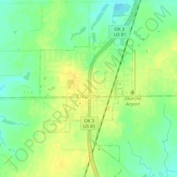
Nombre: Mapa topográfico Okarche, altitud, relieve.
Lugar: Okarche, Kingfisher County, Oklahoma, United States (35.71578 -97.98617 35.73835 -97.96870)
Altitud media: 374 m
Altitud mínima: 361 m
Altitud máxima: 383 m
Otros mapas topográficos
Haga clic en un mapa para ver su topografía, su altitud y su relieve.
Kingfisher
United States > Oklahoma > Kingfisher County
Kingfisher, Kingfisher County, Oklahoma, 73750, United States
Altitud media: 329 m
Omega
United States > Oklahoma > Kingfisher County
Omega, Kingfisher County, Oklahoma, 73764, United States
Altitud media: 367 m
Dover
United States > Oklahoma > Kingfisher County
Dover, Kingfisher County, Oklahoma, 73734, United States
Altitud media: 322 m
Cashion
United States > Oklahoma > Kingfisher County
Cashion, Kingfisher County, Oklahoma, 73016, United States
Altitud media: 339 m
Loyal
United States > Oklahoma > Kingfisher County
Loyal, Kingfisher County, Oklahoma, United States
Altitud media: 344 m