
Mapa topográfico Třebíč
Mapa interactivo
Haga clic en el mapa para ver la altitud.
Acerca de este mapa
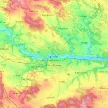
Nombre: Mapa topográfico Třebíč, altitud, relieve.
Lugar: Třebíč, okres Třebíč, Kraj Vysočina, Southeast, Czechia (49.16576 15.81154 49.26991 15.95305)
Altitud media: 479 m
Altitud mínima: 386 m
Altitud máxima: 596 m
Třebíč is situated 35 km southeast of Jihlava and 65 km west of Brno on the Jihlava River. The town's elevation is between 392 and 503 metres above sea-level.