
Haz una donación
Equípate para tu próxima aventura:
Como asociado de Amazon, este sitio gana comisiones por las compras que califican, sin ningún costo adicional para usted.
Mapa topográfico West Town
Haga clic en el mapa para ver la altitud.
Haz una donación
Equípate para tu próxima aventura:
Como asociado de Amazon, este sitio gana comisiones por las compras que califican, sin ningún costo adicional para usted.
Acerca de este mapa
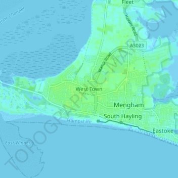
Nombre: Mapa topográfico West Town, altitud, relieve.
Altitud media: 2 m
Altitud mínima: -3 m
Altitud máxima: 9 m
Haz una donación
Equípate para tu próxima aventura:
Como asociado de Amazon, este sitio gana comisiones por las compras que califican, sin ningún costo adicional para usted.
Otros mapas topográficos
Haga clic en un mapa para ver su topografía, su altitud y su relieve.
Hayling Island
United Kingdom > England > Hampshire > Havant > North Hayling
An Iron Age shrine in the north of Hayling Island was later developed into a Roman temple in the 1st century BC and was first recorded in Richard Scott's Topographical and Historical Account of Hayling Island (1826). The site was dug between 1897 and 1907 and again from 1976 to 1978. The remains are now buried…
Altitud media: 1 m
Hayling Island
United Kingdom > England > Hampshire > Havant > Fleet
An Iron Age shrine in the north of Hayling Island was later developed into a Roman temple in the 1st century BC and was first recorded in Richard Scott's Topographical and Historical Account of Hayling Island (1826). The site was dug between 1897 and 1907 and again from 1976 to 1978. The remains are now buried…
Altitud media: 1 m
Haz una donación
Equípate para tu próxima aventura:
Como asociado de Amazon, este sitio gana comisiones por las compras que califican, sin ningún costo adicional para usted.