
Haz una donación
Equípate para tu próxima aventura:
Como asociado de Amazon, este sitio gana comisiones por las compras que califican, sin ningún costo adicional para usted.
Mapa topográfico Chengguan
Haga clic en el mapa para ver la altitud.
Haz una donación
Equípate para tu próxima aventura:
Como asociado de Amazon, este sitio gana comisiones por las compras que califican, sin ningún costo adicional para usted.
Chengguan
Chengguan (Tibetan: ཁྲེང་ཀོན་གྲོང་རྡལ, Wylie: Khreng kon grong rdal, ZYPY: Chênggoin Chongdai; Chinese: 城关镇; pinyin: Chéngguān Zhèn) is a major town in the historical region of Kham in the eastern Tibet Autonomous Region of China. It is the seat of Karub District and Chamdo Prefecture, and had a population of 45,861 in 2010. It is located about 600 km (370 mi) east of Lhasa. By road, the distance is 1,120 km (700 mi) via the southern route or 1,030 km (640 mi) via the northern route. It is at an altitude of 3,230 m (10,600 ft) at the confluence of the rivers Za Qu and Ngom Qu which form the Lancang River (Mekong).
Haz una donación
Equípate para tu próxima aventura:
Como asociado de Amazon, este sitio gana comisiones por las compras que califican, sin ningún costo adicional para usted.
Acerca de este mapa
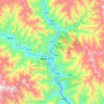
Nombre: Mapa topográfico Chengguan, altitud, relieve.
Lugar: Chengguan, Karuo District, Chamdo City, Tibet, China (31.05757 97.05660 31.26006 97.28312)
Altitud media: 3.929 m
Altitud mínima: 3.191 m
Altitud máxima: 4.941 m
Haz una donación
Equípate para tu próxima aventura:
Como asociado de Amazon, este sitio gana comisiones por las compras que califican, sin ningún costo adicional para usted.