
Mapa topográfico Koloriang
Mapa interactivo
Haga clic en el mapa para ver la altitud.
Acerca de este mapa
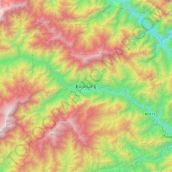
Nombre: Mapa topográfico Koloriang, altitud, relieve.
Altitud media: 1.791 m
Altitud mínima: 498 m
Altitud máxima: 3.508 m
Koloriang is a hilly district headquarters town of Kurung Kumey district in Arunachal Pradesh, India, bordering Tibet. It has an altitude of 1,000 metres (3,300 ft) and is surrounded by high mountains all around and is located in the right bank of river Kurung, one of the major tributaries of Subansiri river. The climate is rainy and hot during summer and very cold in winter. Located at an altitude of 1,040 metres above sea level, this town is also an old administrative centre. It is about 257 km from state capital, Itanagar.