
Mapa topográfico Warwick
Mapa interactivo
Haga clic en el mapa para ver la altitud.
Acerca de este mapa
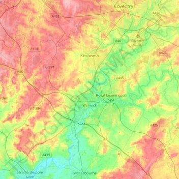
Nombre: Mapa topográfico Warwick, altitud, relieve.
Lugar: Warwick, Warwickshire, West Midlands, England, United Kingdom (52.21370 -1.78018 52.38928 -1.40608)
Altitud media: 87 m
Altitud mínima: 35 m
Altitud máxima: 145 m
Warwick experiences the usual English maritime climate, marked by a narrow temperature range, mild winters and cool summers. The nearest official Met Office weather station is at Wellesbourne, about 6 miles (10 km) south of the town centre and at a similar elevation.
Otros mapas topográficos
Haga clic en un mapa para ver su topografía, su altitud y su relieve.
Warwick Castle
United Kingdom > England > Warwickshire > Warwick
Warwick Castle, Northern Tower, Cliff Hill, Warwick, Warwickshire, England, CV34 4QX, United Kingdom
Altitud media: 56 m
Sherbourne
United Kingdom > England > Warwickshire > Warwick
Sherbourne, Warwick, Warwickshire, England, United Kingdom
Altitud media: 56 m
Leek Wootton
United Kingdom > England > Warwickshire > Warwick
Leek Wootton, Warwick, Warwickshire, England, CV35 7RS, United Kingdom
Altitud media: 76 m