
Haz una donación
Equípate para tu próxima aventura:
Como asociado de Amazon, este sitio gana comisiones por las compras que califican, sin ningún costo adicional para usted.
Mapa topográfico Lichfield
Haga clic en el mapa para ver la altitud.
Haz una donación
Equípate para tu próxima aventura:
Como asociado de Amazon, este sitio gana comisiones por las compras que califican, sin ningún costo adicional para usted.
Acerca de este mapa
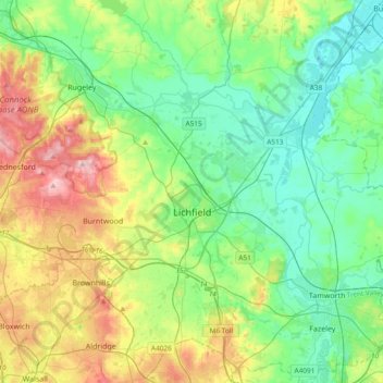
Nombre: Mapa topográfico Lichfield, altitud, relieve.
Lugar: Lichfield, Staffordshire, England, United Kingdom (52.58489 -1.96323 52.80779 -1.58629)
Altitud media: 103 m
Altitud mínima: 43 m
Altitud máxima: 241 m
Haz una donación
Equípate para tu próxima aventura:
Como asociado de Amazon, este sitio gana comisiones por las compras que califican, sin ningún costo adicional para usted.
Otros mapas topográficos
Haga clic en un mapa para ver su topografía, su altitud y su relieve.
Rudyard Lake
United Kingdom > England > Staffordshire > Staffordshire Moorlands > Rudyard > Horton
Altitud media: 205 m
Burton upon Trent
United Kingdom > England > Staffordshire > East Staffordshire
Burton is about 109 miles (175 km) north west of London, about 30 miles north east of Birmingham, the UK's second largest city and about 23 miles east of the county town Stafford. It is at the easternmost border of the county of Staffordshire with Derbyshire, its suburbs and the course of the River Trent…
Altitud media: 69 m
Ashley Dale
United Kingdom > England > Staffordshire > Newcastle-under-Lyme > Loggerheads
Altitud media: 172 m
Haz una donación
Equípate para tu próxima aventura:
Como asociado de Amazon, este sitio gana comisiones por las compras que califican, sin ningún costo adicional para usted.
College Gardens
United Kingdom > England > Staffordshire > Newcastle-under-Lyme > Madeley
Altitud media: 123 m
Tutbury Castle
United Kingdom > England > Staffordshire > East Staffordshire > Tutbury
Altitud media: 66 m
Haz una donación
Equípate para tu próxima aventura:
Como asociado de Amazon, este sitio gana comisiones por las compras que califican, sin ningún costo adicional para usted.
Stubwood
United Kingdom > England > Staffordshire > East Staffordshire > Denstone
Altitud media: 113 m
Birch Cross
United Kingdom > England > Staffordshire > East Staffordshire > Marchington
Altitud media: 92 m
Haz una donación
Equípate para tu próxima aventura:
Como asociado de Amazon, este sitio gana comisiones por las compras que califican, sin ningún costo adicional para usted.
Wain Lea
United Kingdom > England > Staffordshire > Newcastle-under-Lyme > Harriseahead
Altitud media: 207 m
Haz una donación
Equípate para tu próxima aventura:
Como asociado de Amazon, este sitio gana comisiones por las compras que califican, sin ningún costo adicional para usted.
Weston Park
United Kingdom > England > Staffordshire > South Staffordshire > Weston under Lizard
Altitud media: 113 m
Haz una donación
Equípate para tu próxima aventura:
Como asociado de Amazon, este sitio gana comisiones por las compras que califican, sin ningún costo adicional para usted.
Stepping Stones
United Kingdom > England > Staffordshire > Staffordshire Moorlands
Altitud media: 224 m
Haz una donación
Equípate para tu próxima aventura:
Como asociado de Amazon, este sitio gana comisiones por las compras que califican, sin ningún costo adicional para usted.
Bottomhouse
United Kingdom > England > Staffordshire > Staffordshire Moorlands > Ipstones
Altitud media: 312 m
Haz una donación
Equípate para tu próxima aventura:
Como asociado de Amazon, este sitio gana comisiones por las compras que califican, sin ningún costo adicional para usted.
Apedale
United Kingdom > England > Staffordshire > Newcastle-under-Lyme > Chesterton
Altitud media: 168 m
Levedale
United Kingdom > England > Staffordshire > South Staffordshire > Penkridge
Altitud media: 98 m
Roughcote
United Kingdom > England > Staffordshire > Staffordshire Moorlands > Caverswall
Altitud media: 217 m
Haz una donación
Equípate para tu próxima aventura:
Como asociado de Amazon, este sitio gana comisiones por las compras que califican, sin ningún costo adicional para usted.
Blackshaw Moor
United Kingdom > England > Staffordshire > Staffordshire Moorlands > Thorncliffe
Altitud media: 282 m
Castle Ring
United Kingdom > England > Staffordshire > Cannock Chase > Cannock Wood
It is the highest point on The Chase with an elevation of 242 metres (794 ft).
Altitud media: 191 m
Haz una donación
Equípate para tu próxima aventura:
Como asociado de Amazon, este sitio gana comisiones por las compras que califican, sin ningún costo adicional para usted.
Haz una donación
Equípate para tu próxima aventura:
Como asociado de Amazon, este sitio gana comisiones por las compras que califican, sin ningún costo adicional para usted.
Newcastle-under-Lyme
United Kingdom > England > Staffordshire > Newcastle-under-Lyme
Altitud media: 147 m
Bignall End
United Kingdom > England > Staffordshire > Newcastle-under-Lyme > Audley
Altitud media: 150 m
Haz una donación
Equípate para tu próxima aventura:
Como asociado de Amazon, este sitio gana comisiones por las compras que califican, sin ningún costo adicional para usted.
Blithfield Reservoir
United Kingdom > England > Staffordshire > East Staffordshire > Admaston
Altitud media: 108 m
Haz una donación
Equípate para tu próxima aventura:
Como asociado de Amazon, este sitio gana comisiones por las compras que califican, sin ningún costo adicional para usted.
Lower Lee
United Kingdom > England > Staffordshire > Staffordshire Moorlands > Meerbrook > Lower Lee
Altitud media: 264 m
Betley Mere
United Kingdom > England > Staffordshire > Borough of Newcastle-under-Lyme > Wrinehill > Cracow Moss
Altitud media: 81 m
Haz una donación
Equípate para tu próxima aventura:
Como asociado de Amazon, este sitio gana comisiones por las compras que califican, sin ningún costo adicional para usted.
Horton
United Kingdom > England > Staffordshire > Staffordshire Moorlands > Gratton
Altitud media: 199 m
Haz una donación
Equípate para tu próxima aventura:
Como asociado de Amazon, este sitio gana comisiones por las compras que califican, sin ningún costo adicional para usted.
Wood Lane
United Kingdom > England > Staffordshire > Newcastle-under-Lyme > Bignall Hill
Altitud media: 168 m
Rushton Spencer
United Kingdom > England > Staffordshire > Staffordshire Moorlands
Altitud media: 204 m
Haz una donación
Equípate para tu próxima aventura:
Como asociado de Amazon, este sitio gana comisiones por las compras que califican, sin ningún costo adicional para usted.
Calf Heath
United Kingdom > England > Staffordshire > South Staffordshire > Hatherton Junction
Altitud media: 113 m
Chasewater
United Kingdom > England > Staffordshire > Lichfield > Burntwood > Chasetown
Altitud media: 155 m
Haz una donación
Equípate para tu próxima aventura:
Como asociado de Amazon, este sitio gana comisiones por las compras que califican, sin ningún costo adicional para usted.
Old Hannah's Hole
United Kingdom > England > Staffordshire > Staffordshire Moorlands > Wetton
Altitud media: 276 m
Haz una donación
Equípate para tu próxima aventura:
Como asociado de Amazon, este sitio gana comisiones por las compras que califican, sin ningún costo adicional para usted.
Moneystone
United Kingdom > England > Staffordshire > Staffordshire Moorlands > Cotton
Altitud media: 231 m
Haz una donación
Equípate para tu próxima aventura:
Como asociado de Amazon, este sitio gana comisiones por las compras que califican, sin ningún costo adicional para usted.
Biddulph Grange Country Park
United Kingdom > England > Staffordshire > Staffordshire Moorlands > Biddulph > Biddulph Moor
Altitud media: 229 m
Moneystone Quarry
United Kingdom > England > Staffordshire > Staffordshire Moorlands > Kingsley > Whiston Eaves
Altitud media: 202 m
Haz una donación
Equípate para tu próxima aventura:
Como asociado de Amazon, este sitio gana comisiones por las compras que califican, sin ningún costo adicional para usted.
Hales Hall Pool
United Kingdom > England > Staffordshire > Staffordshire Moorlands > Cheadle
Altitud media: 182 m
Mottey Meadows NNR
United Kingdom > England > Staffordshire > South Staffordshire > Wheaton Aston
Altitud media: 110 m
Haz una donación
Equípate para tu próxima aventura:
Como asociado de Amazon, este sitio gana comisiones por las compras que califican, sin ningún costo adicional para usted.
Whiston
United Kingdom > England > Staffordshire > South Staffordshire > Penkridge
Altitud media: 95 m
Haz una donación
Equípate para tu próxima aventura:
Como asociado de Amazon, este sitio gana comisiones por las compras que califican, sin ningún costo adicional para usted.
Whitmore Heath
United Kingdom > England > Staffordshire > Newcastle-under-Lyme > Whitmore
Altitud media: 141 m
Haz una donación
Equípate para tu próxima aventura:
Como asociado de Amazon, este sitio gana comisiones por las compras que califican, sin ningún costo adicional para usted.
Birks Wood
United Kingdom > England > Staffordshire > Newcastle-under-Lyme > Shraleybrook
Altitud media: 109 m
Gratwich
United Kingdom > England > Staffordshire > East Staffordshire > Kingstone
Altitud media: 143 m
Haz una donación
Equípate para tu próxima aventura:
Como asociado de Amazon, este sitio gana comisiones por las compras que califican, sin ningún costo adicional para usted.
Haz una donación
Equípate para tu próxima aventura:
Como asociado de Amazon, este sitio gana comisiones por las compras que califican, sin ningún costo adicional para usted.
Hope
United Kingdom > England > Staffordshire > Staffordshire Moorlands > Alstonefield
Altitud media: 274 m
Haz una donación
Equípate para tu próxima aventura:
Como asociado de Amazon, este sitio gana comisiones por las compras que califican, sin ningún costo adicional para usted.