
Mapa topográfico Gaintza
Mapa interactivo
Haga clic en el mapa para ver la altitud.
Acerca de este mapa
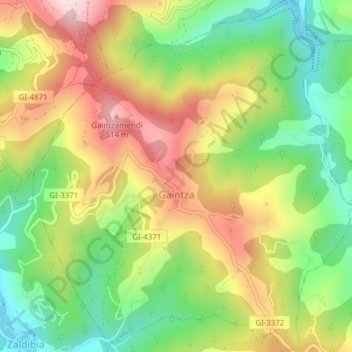
Nombre: Mapa topográfico Gaintza, altitud, relieve.
Altitud media: 327 m
Altitud mínima: 157 m
Altitud máxima: 528 m
Otros mapas topográficos
Haga clic en un mapa para ver su topografía, su altitud y su relieve.
Soil
Spain > Autonomous Community of the Basque Country > Montaña Alavesa/Arabako Mendialdea
Soil, Arraia-Maeztu, Montaña Alavesa/Arabako Mendialdea, Álava, Autonomous Community of the Basque Country, 01207, Spain
Altitud media: 898 m
San Sebastián
Spain > Autonomous Community of the Basque Country
San Sebastián, Gipuzkoa, Autonomous Community of the Basque Country, Spain
Altitud media: 120 m
Orio
Spain > Autonomous Community of the Basque Country > Urola-Kosta
Orio, Urola-Kosta, Gipuzkoa, Autonomous Community of the Basque Country, 20810, Spain
Altitud media: 50 m
Donostia / San Sebastián
Spain > Autonomous Community of the Basque Country > Donostialdea > Donostia / San Sebastián
Donostia / San Sebastián, San Sebastián, Donostialdea, Gipuzkoa, Autonomous Community of the Basque Country, 20003, Spain
Altitud media: 134 m
Bilbao
Spain > Autonomous Community of the Basque Country > Bilbao
Bilbao, Biscay, Autonomous Community of the Basque Country, Spain
Altitud media: 156 m
Legazpi
Spain > Autonomous Community of the Basque Country
Legazpi, Gipuzkoa, Autonomous Community of the Basque Country, Spain
Altitud media: 548 m