
Mapa topográfico Rocester
Haga clic en el mapa para ver la altitud.
Acerca de este mapa
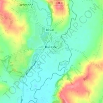
Nombre: Mapa topográfico Rocester, altitud, relieve.
Altitud media: 105 m
Altitud mínima: 79 m
Altitud máxima: 156 m
Otros mapas topográficos
Haga clic en un mapa para ver su topografía, su altitud y su relieve.
Tutbury Castle
United Kingdom > England > Staffordshire > East Staffordshire > Tutbury
Altitud media: 66 m
Burton upon Trent
United Kingdom > England > Staffordshire > East Staffordshire
Burton is about 109 miles (175 km) north west of London, about 30 miles north east of Birmingham, the UK's second largest city and about 23 miles east of the county town Stafford. It is at the easternmost border of the county of Staffordshire with Derbyshire, its suburbs and the course of the River Trent…
Altitud media: 69 m
Stubwood
United Kingdom > England > Staffordshire > East Staffordshire > Denstone
Altitud media: 113 m
Birch Cross
United Kingdom > England > Staffordshire > East Staffordshire > Marchington
Altitud media: 92 m
Blithfield Reservoir
United Kingdom > England > Staffordshire > East Staffordshire > Admaston
Altitud media: 108 m
Gratwich
United Kingdom > England > Staffordshire > East Staffordshire > Kingstone
Altitud media: 143 m
Marchington Woodlands
United Kingdom > England > Staffordshire > East Staffordshire
Altitud media: 120 m
Harlow Wood
United Kingdom > England > Staffordshire > East Staffordshire > Upper Mayfield
Altitud media: 177 m
Burton upon Trent
United Kingdom > England > Staffordshire > East Staffordshire
Burton is about 109 miles (175 km) north west of London, about 30 miles north east of Birmingham, the UK's second largest city and about 23 miles east of the county town Stafford. It is at the easternmost border of the county of Staffordshire with Derbyshire, its suburbs and the course of the River Trent…
Altitud media: 69 m