
Haz una donación
Equípate para tu próxima aventura:
Como asociado de Amazon, este sitio gana comisiones por las compras que califican, sin ningún costo adicional para usted.
Mapa topográfico Neuenahr
Haga clic en el mapa para ver la altitud.
Haz una donación
Equípate para tu próxima aventura:
Como asociado de Amazon, este sitio gana comisiones por las compras que califican, sin ningún costo adicional para usted.
Acerca de este mapa
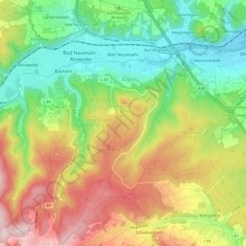
Nombre: Mapa topográfico Neuenahr, altitud, relieve.
Altitud media: 242 m
Altitud mínima: 75 m
Altitud máxima: 472 m
Haz una donación
Equípate para tu próxima aventura:
Como asociado de Amazon, este sitio gana comisiones por las compras que califican, sin ningún costo adicional para usted.
Otros mapas topográficos
Haga clic en un mapa para ver su topografía, su altitud y su relieve.
Landskrone
Deutschland > Rheinland-Pfalz > Landkreis Ahrweiler > Bad Neuenahr-Ahrweiler
Ahrschleife bei Altenahr | An der Teufelsley | Aremberg | Bausenberg | Dachsbusch | Hohe Acht | Hürs-Nück | In der Burwies | Laacher See | Landskrone | Lehrenkopf | Meirother Kopf und Tiefenstein | Mündungsgebiet der Ahr | Nürburg | Quiddelbacher Höhe / Nürburgring | Olbrück | Perler Kopf | Quellgebiet…
Altitud media: 129 m
Neuenahrer Berg
Deutschland > Rheinland-Pfalz > Landkreis Ahrweiler > Bad Neuenahr-Ahrweiler
Altitud media: 213 m