
Haz una donación
Equípate para tu próxima aventura:
Como asociado de Amazon, este sitio gana comisiones por las compras que califican, sin ningún costo adicional para usted.
Mapa topográfico Madison
Haga clic en el mapa para ver la altitud.
Haz una donación
Equípate para tu próxima aventura:
Como asociado de Amazon, este sitio gana comisiones por las compras que califican, sin ningún costo adicional para usted.
Madison
The city is sometimes described as The City of Four Lakes, comprising the four successive lakes of the Yahara River: Lake Mendota ("Fourth Lake"), Lake Monona ("Third Lake"), Lake Waubesa ("Second Lake") and Lake Kegonsa ("First Lake"), although Waubesa and Kegonsa are not actually in Madison, but just south of it. A fifth smaller lake, Lake Wingra, is within the city as well; it is connected to the Yahara River chain by Wingra Creek. The Yahara flows into the Rock River, which flows into the Mississippi River. Downtown Madison is located on an isthmus between Lakes Mendota and Monona. The city's trademark of "Lake, City, Lake" reflects this geography. The city's lowest elevation is Lake Monona, at 845 ft (257.5 m). The highest elevation is located along S. Pleasant View Rd on the far westside of the city, atop a portion of a terminal moraine of the Green Bay Lobe of the Wisconsin Glaciation, at 1192 ft (363.3 m).
Haz una donación
Equípate para tu próxima aventura:
Como asociado de Amazon, este sitio gana comisiones por las compras que califican, sin ningún costo adicional para usted.
Acerca de este mapa
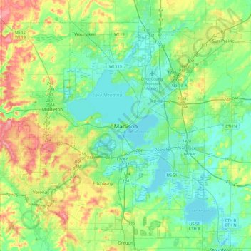
Nombre: Mapa topográfico Madison, altitud, relieve.
Lugar: Madison, Dane County, Wisconsin, 53703, United States (42.91476 -89.54376 43.23476 -89.22376)
Altitud media: 289 m
Altitud mínima: 255 m
Altitud máxima: 377 m
Haz una donación
Equípate para tu próxima aventura:
Como asociado de Amazon, este sitio gana comisiones por las compras que califican, sin ningún costo adicional para usted.