
Mapa topográfico Rittershof
Haga clic en el mapa para ver la altitud.
Rittershof
Altenhof | Auhof | Autobahnmeisterei Neumarkt i.d.OPf. | Beckenmühle | Blomenhof | Bodenhof | Bodenmühle | Eichenmühle | Frickenhofen | Friedlmühle | Fuchsberg | Großwiesenhof | Guglhof | Habersmühle | Helena | Höhenberg | Höhenberg im Tal | Holzheim | Iberlsmühle | Ischhofen | Karhof | Kohlenbrunnermühle | Koppenmühle | Labersricht | Lähr | Lampertshofen | Lippertshofen | Neumarkt in der Oberpfalz | Ottosau | Pelchenhofen | Pölling | Rittershof | Rödelberg | Schafhof | Schleifmühle | Schmermühle | Schönmühle | Stauf | Steinberg | Tiefenbrunn | Ungenricht | Voggenthal | Woffenbach | Wolfstein | Wolfstein
Acerca de este mapa
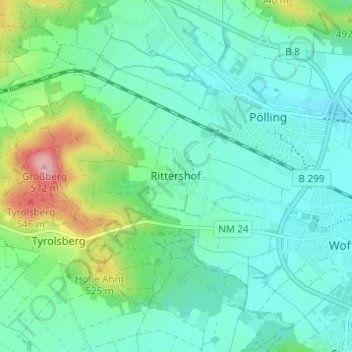
Nombre: Mapa topográfico Rittershof, altitud, relieve.
Altitud media: 455 m
Altitud mínima: 420 m
Altitud máxima: 572 m
Otros mapas topográficos
Haga clic en un mapa para ver su topografía, su altitud y su relieve.
92318
Deutschland > Bayern > Landkreis Neumarkt in der Oberpfalz > Neumarkt in der Oberpfalz > Höhenberg im Tal
Altitud media: 513 m