
Haz una donación
Equípate para tu próxima aventura:
Como asociado de Amazon, este sitio gana comisiones por las compras que califican, sin ningún costo adicional para usted.
Mapa topográfico Beatty
Haga clic en el mapa para ver la altitud.
Haz una donación
Equípate para tu próxima aventura:
Como asociado de Amazon, este sitio gana comisiones por las compras que califican, sin ningún costo adicional para usted.
Acerca de este mapa
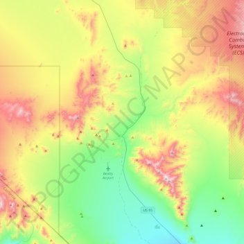
Nombre: Mapa topográfico Beatty, altitud, relieve.
Lugar: Beatty, Nye County, Nevada, 89003, United States (36.74182 -116.82088 37.11714 -116.58894)
Altitud media: 1.233 m
Altitud mínima: 822 m
Altitud máxima: 1.907 m
Haz una donación
Equípate para tu próxima aventura:
Como asociado de Amazon, este sitio gana comisiones por las compras que califican, sin ningún costo adicional para usted.
Otros mapas topográficos
Haga clic en un mapa para ver su topografía, su altitud y su relieve.
Amargosa Valley
United States > Nevada > Nye County
Amargosa Valley is located at 36.58001 North, 116.44487 West at an elevation of 2,640 feet (805 m) above sea level. The landscape is typical of lower to moderate elevations in the Mojave Desert, with flat expanses of sandy soil punctuated by rocky mounds and hills. Predominant indigenous vegetation is White…
Altitud media: 740 m
Devils Hole
United States > Nevada > Nye County
Devils Hole is a geothermal pool within a limestone cavern in the Amargosa Desert in the Amargosa Valley of Nevada, east over the Amargosa Range and Funeral Mountains from Death Valley. It is at an elevation of 730 m (2,400 ft) above sea level and the water is a constant temperature of 33 °C (91 °F). The…
Altitud media: 756 m
Haz una donación
Equípate para tu próxima aventura:
Como asociado de Amazon, este sitio gana comisiones por las compras que califican, sin ningún costo adicional para usted.