
Mapa topográfico Ευρώτας
Mapa interactivo
Haga clic en el mapa para ver la altitud.
Acerca de este mapa
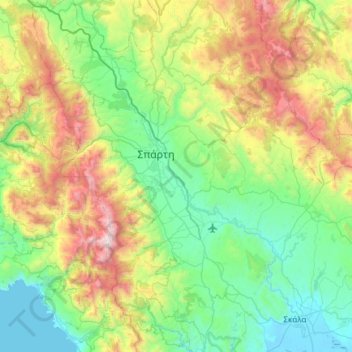
Nombre: Mapa topográfico Ευρώτας, altitud, relieve.
Altitud media: 656 m
Altitud mínima: -3 m
Altitud máxima: 2.367 m
Logaras Spring supplies an anciently constructed catchment basin about the size of a pond, sometimes called a lake, which exits both to irrigation channels and to the Alpheios stream (not to be confused with the Alpheios river in the northwestern Peloponnese). The flow is copious except in times of drought. A recent study measured the outflow through the catchment exit every 15 days for 540 days in 2006-2007. It recorded a maximum of 1748 cubic m per hour and a minimum of 310.5 cubic m per hour. From the catchment at an altitude of 430 m (1,410 ft) part of the water flows into the Alpheios stream, which enters the upper Eurotas.
Otros mapas topográficos
Haga clic en un mapa para ver su topografía, su altitud y su relieve.
Municipal Unit of Sparta
Greece > Peloponnese, Western Greece and the Ionian > Laconia Regional Unit
Municipal Unit of Sparta, Municipality of Sparta, Laconia Regional Unit, Peloponnese Region, Peloponnese, Western Greece and the Ionian, 231 00, Greece
Altitud media: 450 m
Lagia
Greece > Peloponnese, Western Greece and the Ionian > Laconia Regional Unit > East Mani Municipal Unit
Lagia, East Mani Municipal Unit, Municipality of East Mani, Laconia Regional Unit, Peloponnese Region, Peloponnese, Western Greece and the Ionian, 230 71, Greece
Altitud media: 317 m
Sparta
Greece > Peloponnese, Western Greece and the Ionian > Laconia Regional Unit
Sparta, Municipality of Sparta, Laconia Regional Unit, Peloponnese Region, Peloponnese, Western Greece and the Ionian, 231 00, Greece
Altitud media: 198 m
Monemvasia
Greece > Peloponnese, Western Greece and the Ionian > Laconia Regional Unit
Monemvasia, Municipality of Monemvasia, Laconia Regional Unit, Peloponnese Region, Peloponnese, Western Greece and the Ionian, Greece
Altitud media: 7 m
Sparta
Greece > Peloponnese, Western Greece and the Ionian > Laconia Regional Unit > Municipality of Sparta > Χαρίσιο
Sparta, Τριακοσίων, Χαρίσιο, Municipality of Sparta, Laconia Regional Unit, Peloponnese Region, Peloponnese, Western Greece and the Ionian, 23100, Greece
Altitud media: 214 m
Municipality of Sparta
Greece > Peloponnese, Western Greece and the Ionian > Laconia Regional Unit
Municipality of Sparta, Laconia Regional Unit, Peloponnese Region, Peloponnese, Western Greece and the Ionian, Greece
Altitud media: 699 m
Molai
Greece > Peloponnese, Western Greece and the Ionian > Laconia Regional Unit > Molai
Molai, Municipality of Monemvasia, Laconia Regional Unit, Peloponnese Region, Peloponnese, Western Greece and the Ionian, 230 52, Greece
Altitud media: 260 m