
Mapa topográfico La Chenal
Mapa interactivo
Haga clic en el mapa para ver la altitud.
Acerca de este mapa
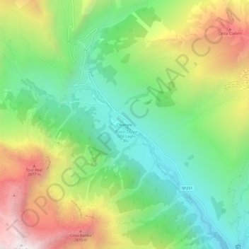
Nombre: Mapa topográfico La Chenal, altitud, relieve.
Lugar: La Chenal, Pontechianale, Coni, Piémont, Italie (44.62665 6.97869 44.66665 7.01869)
Altitud media: 2.223 m
Altitud mínima: 1.660 m
Altitud máxima: 3.108 m
Otros mapas topográficos
Haga clic en un mapa para ver su topografía, su altitud y su relieve.
Gr. dell'Agnello
Italie > Piémont > Coni > Pontechianale
Gr. dell'Agnello, Pontechianale, Coni, Piémont, Italie
Altitud media: 2.400 m
Castello
Italie > Piémont > Coni > Pontechianale
Castello, Pontechianale, Coni, Piémont, Italie
Altitud media: 1.901 m
Fonte
Italie > Piémont > Coni > Pontechianale
Fonte, Monviso - via normale, Pontechianale, Coni, Piémont, Italie
Altitud media: 2.690 m
Col Agnel
Italie > Piémont > Coni > Pontechianale
Col Agnel, Pontechianale, Coni, Piémont, Italie
Altitud media: 2.700 m