
Mapa topográfico Almetyevsky District
Mapa interactivo
Haga clic en el mapa para ver la altitud.
Acerca de este mapa
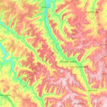
Nombre: Mapa topográfico Almetyevsky District, altitud, relieve.
Altitud media: 194 m
Altitud mínima: 67 m
Altitud máxima: 348 m
The district is located in the northwest of the Bugulma plateau and the elevation of the district ranges from 200 to 300 meters. The regional rivers Kichuy, Stepnoy Zai and Ursalbash along with their tributaries are among the waterways flowing through the district. The region holds reserves of oil, coal and other mineral resources. The regional climate is temperate continental with cool summers and cold winters.
Otros mapas topográficos
Haga clic en un mapa para ver su topografía, su altitud y su relieve.
Билярск
Russia > Tatarstan > Alexeyevsky District
Билярск, Билярское сельское поселение, Alexeyevsky District, Tatarstan, Volga Federal District, 422920, Russia
Altitud media: 114 m
Apastovo
Russia > Tatarstan > Apastovsky District
Apastovo, городское поселение Апастово, Apastovsky District, Tatarstan, Volga Federal District, 422350, Russia
Altitud media: 120 m
Naberezhnye Chelny
Naberezhnye Chelny, Tatarstan, Volga Federal District, Russia
Altitud media: 115 m
Almetyevsk
Russia > Tatarstan > Almetyevsk
Almetyevsk, Almetyevsky District, Tatarstan, Volga Federal District, 423457, Russia
Altitud media: 205 m
Самарканд
Russia > Tatarstan > Маметьевское сельское поселение > Самарканд
Самарканд, Маметьевское сельское поселение, Almetyevsky District, Tatarstan, Volga Federal District, Russia
Altitud media: 235 m
Naberezhnye Chelny
Russia > Tatarstan > городской округ Набережные Челны
Naberezhnye Chelny, городской округ Набережные Челны, Tatarstan, Volga Federal District, Russia
Altitud media: 115 m
Almetyevsk
Russia > Tatarstan > Almetyevsk
Almetyevsk, Almetyevsky District, Tatarstan, Volga Federal District, Russia
Altitud media: 167 m
Nizhnekamsk Reservoir
Russia > Tatarstan > Малошильнинское сельское поселение
Nizhnekamsk Reservoir, Малошильнинское сельское поселение, Tukayevsky District, Tatarstan, Volga Federal District, Russia
Altitud media: 129 m