
Mapa topográfico Ruse
Mapa interactivo
Haga clic en el mapa para ver la altitud.
Ruse
Ruse is on the right bank of the river Danube, which is the high bank, having two underwater terraces and three river terraces at 15 to 22 m (49.21–72.18 ft), 30 to 66 m (98.43–216.54 ft), and 54 to 65 m (177.17–213.25 ft). The average altitude is 45.5 m (149.28 ft) AMSL. The urban area is an approximately 11-km ellipse running along the river. The city extends from the land-connected Matey (Матей) island and the mouth of Rusenski Lom on the west to Srabcheto (Сръбчето) hill on the east. During the 20th century, the west end of the city was significantly modified by moving the mouth of Rusenski Lom to the west, as well as by moving the bank itself with its fairway considerably to the north. Sarabair (саръбаир, from Turkish Sarıbayır meaning "Yellow Slope") hill is to the south of the city and is 159 m (521.65 ft) high. The Rousse TV Tower is built there on the remains of Leventtabia, a former Turkish fortification.
Acerca de este mapa
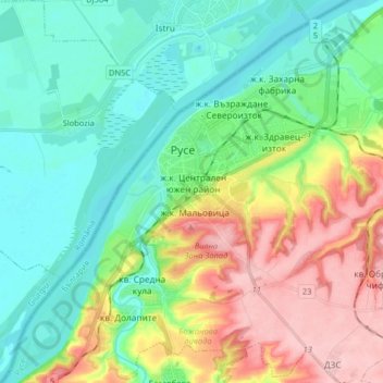
Nombre: Mapa topográfico Ruse, altitud, relieve.
Lugar: Ruse, Bulgaria (43.77989 25.90529 43.89024 26.06729)
Altitud media: 64 m
Altitud mínima: 12 m
Altitud máxima: 166 m