
Mapa topográfico Reisach
Haga clic en el mapa para ver la altitud.
Reisach
Birklmühle | Bodendorf | Bronn | Buchau | Büchenbach | Großkrausmühle | Haidmühle | Hainbronn | Hammerbühl | Hedelmühle | Heroldsreuth | Herrenmühle | Hollenberg | Horlach | Hufeisen-Waldhaus | Kaltenthal | Kleinkrausmühle | Körbeldorf | Kosbrunn | Kotzenhammer | Langenreuth | Lehm | Leups | Leupsermühle | Lobensteig | Lüglas | Nemschenreuth | Neudorf | Neuhof | Oberhauenstein | Pegnitz (Kernbereich) | Penzenreuth | Pertenhof | Reisach | Rosenhof | Scharthammer | Stein | Stemmenreuth | Trockau | Troschenreuth | Unterhauenstein | Vestenmühle | Weidelwangermühle | Weidmannshöhe | Willenberg | Willenreuth | Wolfslohe | Ziegelhütte | Zips
Acerca de este mapa
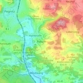
Nombre: Mapa topográfico Reisach, altitud, relieve.
Altitud media: 466 m
Altitud mínima: 403 m
Altitud máxima: 564 m