
Mapa topográfico Big Harbour Island
Mapa interactivo
Haga clic en el mapa para ver la altitud.
Acerca de este mapa
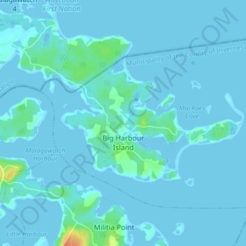
Nombre: Mapa topográfico Big Harbour Island, altitud, relieve.
Altitud media: 3 m
Altitud mínima: -6 m
Altitud máxima: 42 m
Otros mapas topográficos
Haga clic en un mapa para ver su topografía, su altitud y su relieve.
Dunmore
Canada > Nova Scotia > Municipality of the County of Inverness
Dunmore, Municipality of the County of Inverness, Inverness County, Nova Scotia, Canada
Altitud media: 28 m
Mabou Harbour
Canada > Nova Scotia > Municipality of the County of Inverness > West Mabou
Mabou Harbour, West Mabou, Municipality of the County of Inverness, Inverness County, Nova Scotia, Canada
Altitud media: 51 m
Gull Island
Canada > Nova Scotia > Municipality of the County of Inverness > Big Harbour Island
Gull Island, Big Harbour Island, Municipality of the County of Inverness, Inverness County, Nova Scotia, Canada
Altitud media: 74 m