
Mapa topográfico Paris
Mapa interactivo
Haga clic en el mapa para ver la altitud.
Acerca de este mapa
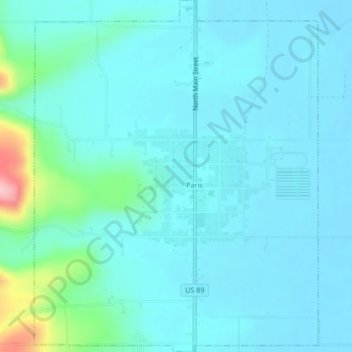
Nombre: Mapa topográfico Paris, altitud, relieve.
Lugar: Paris, Bear Lake County, Idaho, 83261, United States (42.21227 -111.42036 42.24362 -111.38607)
Altitud media: 1.831 m
Altitud mínima: 1.807 m
Altitud máxima: 1.978 m
Paris lies in a high valley of the Rocky Mountains, at nearly 6,000 feet (1,830 m) in elevation.
Otros mapas topográficos
Haga clic en un mapa para ver su topografía, su altitud y su relieve.
Bern
United States > Idaho > Bear Lake County
Bern, Bear Lake County, Idaho, 83220, United States
Altitud media: 1.858 m
Montpelier
United States > Idaho > Bear Lake County > Montpelier
Montpelier, Bear Lake County, Idaho, 83254, United States
Altitud media: 1.842 m
St. Charles
United States > Idaho > Bear Lake County > St. Charles
St. Charles, Bear Lake County, Idaho, 83272, United States
Altitud media: 1.830 m