
Haz una donación
Equípate para tu próxima aventura:
Como asociado de Amazon, este sitio gana comisiones por las compras que califican, sin ningún costo adicional para usted.
Mapa topográfico Liberty Lake
Haga clic en el mapa para ver la altitud.
Haz una donación
Equípate para tu próxima aventura:
Como asociado de Amazon, este sitio gana comisiones por las compras que califican, sin ningún costo adicional para usted.
Liberty Lake
Areas east of Liberty Lake Road and areas north of Appleway Road lie on the relatively flat land along the floor of the Spokane Valley. Elevations there range from between 2,000 feet above sea level at the river to around 2,150 feet around Liberty Lake Elementary School. The areas west of Liberty Lake Road and south of Appleway Road show far more topographical relief, rising from around 2,100 feet to over 2,600 feet on Carlson Hill. Kramer Hill, which rises just beyond the eastern limit of the city, quickly rises to above 2,700 feet. While Mica Peak, which rises beyond the southern shore of the lake, climbs to nearly 5,200 feet.
Haz una donación
Equípate para tu próxima aventura:
Como asociado de Amazon, este sitio gana comisiones por las compras que califican, sin ningún costo adicional para usted.
Acerca de este mapa
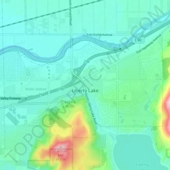
Nombre: Mapa topográfico Liberty Lake, altitud, relieve.
Lugar: Liberty Lake, Spokane County, Washington, United States (47.64954 -117.14347 47.68995 -117.06333)
Altitud media: 644 m
Altitud mínima: 603 m
Altitud máxima: 816 m
Haz una donación
Equípate para tu próxima aventura:
Como asociado de Amazon, este sitio gana comisiones por las compras que califican, sin ningún costo adicional para usted.
Otros mapas topográficos
Haga clic en un mapa para ver su topografía, su altitud y su relieve.
Mica Peak
United States > Washington > Spokane County
Mica Peak is the name of two separate mountain summits in the United States located approximately 5.49 miles (9 km) apart; one in Spokane County, Washington and the other in Kootenai County, Idaho. The two peaks are located along the same ridge, which separates the Spokane Valley and Rathdrum Prairie from the…
Altitud media: 1.311 m
Haz una donación
Equípate para tu próxima aventura:
Como asociado de Amazon, este sitio gana comisiones por las compras que califican, sin ningún costo adicional para usted.
Haz una donación
Equípate para tu próxima aventura:
Como asociado de Amazon, este sitio gana comisiones por las compras que califican, sin ningún costo adicional para usted.
Haz una donación
Equípate para tu próxima aventura:
Como asociado de Amazon, este sitio gana comisiones por las compras que califican, sin ningún costo adicional para usted.
Haz una donación
Equípate para tu próxima aventura:
Como asociado de Amazon, este sitio gana comisiones por las compras que califican, sin ningún costo adicional para usted.
Mica Peak
United States > Washington > Spokane County
Mica Peak is the name of two separate mountain summits in the United States located approximately 5.49 miles (9 km) apart; one in Spokane County, Washington and the other in Kootenai County, Idaho. The two peaks are located along the same ridge, which separates the Spokane Valley and Rathdrum Prairie from the…
Altitud media: 1.311 m
East Spokane
United States > Washington > Spokane County > Spokane Valley > East Spokane
Altitud media: 625 m
Haz una donación
Equípate para tu próxima aventura:
Como asociado de Amazon, este sitio gana comisiones por las compras que califican, sin ningún costo adicional para usted.