
Mapa topográfico Trento
Mapa interactivo
Haga clic en el mapa para ver la altitud.
Acerca de este mapa
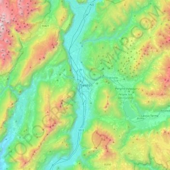
Nombre: Mapa topográfico Trento, altitud, relieve.
Altitud media: 970 m
Altitud mínima: 93 m
Altitud máxima: 3.117 m
Trento has a humid subtropical-continental climate (Cfa-Dfa) through most of its populated areas according to the Köppen climate classification. Boroughs at higher elevation like Viote have a colder alpine climate (Dw). Monthly average temperatures range between 1.6 °C (January) and 23.4 °C (July). Annual precipitation exceed 900 mm spread out on an average of 87 days, with peaks in late spring (May–June, 90 mm monthly average in 9–10 rain days) and autumn (October–November: 100–110 mm monthly average in 7–8 days), and lows in winter (January–February, 30–40 mm monthly average in 3–4 rain days).
Otros mapas topográficos
Haga clic en un mapa para ver su topografía, su altitud y su relieve.
Roncafort
Italy > Trentino-Alto Adige/Südtirol > Provincia di Trento > Trento
Roncafort, Trento, Territorio Val d'Adige, Provincia di Trento, Trentino-Alto Adige/Südtirol, 38121, Italy
Altitud media: 341 m