
Mapa topográfico Toomaline Upper
Haga clic en el mapa para ver la altitud.
Acerca de este mapa
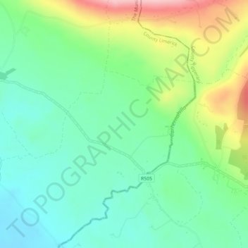
Nombre: Mapa topográfico Toomaline Upper, altitud, relieve.
Altitud media: 122 m
Altitud mínima: 66 m
Altitud máxima: 240 m
Otros mapas topográficos
Haga clic en un mapa para ver su topografía, su altitud y su relieve.
Kilcruaig
Ireland > County Limerick > The Municipal District of Cappamore — Kilmallock
Altitud media: 200 m
Knockadea
Ireland > County Limerick > The Municipal District of Cappamore — Kilmallock
Altitud media: 203 m
Pallasgreen
Ireland > County Limerick > The Municipal District of Cappamore — Kilmallock
Altitud media: 72 m
Galtymore
Ireland > County Limerick > The Municipal District of Cappamore — Kilmallock
Galtymore or Galteemore (Irish: Cnoc Mór na nGaibhlte, meaning 'big hill of the Galtees') is a mountain in the province of Munster, Ireland. At 917.9 metres (3,011 ft 6 in), it is one of Ireland's highest mountains, being the 12th-highest on the Arderin list, and 14th-highest on the Vandeleur-Lynam list.…
Altitud media: 594 m
Aherlow
Ireland > County Limerick > The Municipal District of Cappamore — Kilmallock
Altitud media: 141 m
Clare Glens
Ireland > County Limerick > The Municipal District of Cappamore — Kilmallock
Altitud media: 124 m
Ardpatrick
Ireland > County Limerick > The Municipal District of Cappamore — Kilmallock
Altitud media: 169 m
Bruff
Ireland > County Limerick > The Municipal District of Cappamore — Kilmallock
Altitud media: 68 m
Bruree
Ireland > County Limerick > The Municipal District of Cappamore — Kilmallock
Altitud media: 62 m