
Haz una donación
Equípate para tu próxima aventura:
Como asociado de Amazon, este sitio gana comisiones por las compras que califican, sin ningún costo adicional para usted.
Mapa topográfico San Bernardino National Forest
Haga clic en el mapa para ver la altitud.
Haz una donación
Equípate para tu próxima aventura:
Como asociado de Amazon, este sitio gana comisiones por las compras que califican, sin ningún costo adicional para usted.
San Bernardino National Forest
The San Bernardino National Forest is a United States National Forest in Southern California encompassing 823,816 acres (3,333.87 km2) of which 677,982 acres (2,743.70 km2) are federal. The forest is made up of two main divisions, the eastern portion of the San Gabriel Mountains and the San Bernardino Mountains on the easternmost of the Transverse Ranges, and the San Jacinto and Santa Rosa Mountains on the northernmost of the Peninsular Ranges. Elevations range from 2,000 to 11,499 feet (600 to 3505 m). The forest includes seven wilderness areas: San Gorgonio, Cucamonga, San Jacinto, South Fork, Santa Rosa, Cahuilla Mountain and Bighorn Mountain. Forest headquarters are located in the city of San Bernardino. There are district offices in Lytle Creek, Idyllwild, and Fawnskin.
Haz una donación
Equípate para tu próxima aventura:
Como asociado de Amazon, este sitio gana comisiones por las compras que califican, sin ningún costo adicional para usted.
Acerca de este mapa
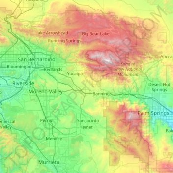
Nombre: Mapa topográfico San Bernardino National Forest, altitud, relieve.
Altitud media: 1.009 m
Altitud mínima: 71 m
Altitud máxima: 3.487 m
Haz una donación
Equípate para tu próxima aventura:
Como asociado de Amazon, este sitio gana comisiones por las compras que califican, sin ningún costo adicional para usted.
Otros mapas topográficos
Haga clic en un mapa para ver su topografía, su altitud y su relieve.
Cajon Pass
United States > California > San Bernardino County
Cajon Pass (/kəˈhoʊn/; Spanish: Puerto del Cajón or Paso del Cajón) is a mountain pass between the San Bernardino Mountains to the east and the San Gabriel Mountains to the west in Southern California. Created by the movements of the San Andreas Fault, it has an elevation of 3,777 ft (1,151 m). Located in…
Altitud media: 1.169 m
Haz una donación
Equípate para tu próxima aventura:
Como asociado de Amazon, este sitio gana comisiones por las compras que califican, sin ningún costo adicional para usted.
Haz una donación
Equípate para tu próxima aventura:
Como asociado de Amazon, este sitio gana comisiones por las compras que califican, sin ningún costo adicional para usted.
Fort Irwin
United States > California > San Bernardino County
Fort Irwin National Training Center (Fort Irwin NTC) is a major training area for the United States military in the Mojave Desert in northern San Bernardino County, California. Fort Irwin is at an average elevation of 2,454 feet (748 m). It is located 37 miles (60 km) northeast of Barstow, in the Calico…
Altitud media: 774 m
Meadowbrook Woods
United States > California > San Bernardino County > Lake Arrowhead
Altitud media: 1.560 m
Haz una donación
Equípate para tu próxima aventura:
Como asociado de Amazon, este sitio gana comisiones por las compras que califican, sin ningún costo adicional para usted.
Running Springs
United States > California > San Bernardino County > Running Springs
Running Springs is a mountain community in the San Bernardino Mountains. It is an inholding in the San Bernardino National Forest. Situated at the junction of State Route 18 and State Route 330, it is a major gateway to the mountain communities of Lake Arrowhead, Arrowbear, Green Valley Lake, and Big Bear and…
Altitud media: 1.656 m
Haz una donación
Equípate para tu próxima aventura:
Como asociado de Amazon, este sitio gana comisiones por las compras que califican, sin ningún costo adicional para usted.
San Gorgonio Mountain
United States > California > San Bernardino County
Since it is the highest point in a region which is separated from higher peaks (e.g. in the Sierra Nevada) by relatively low terrain, San Gorgonio Mountain is one of the most topographically prominent peaks in the United States. It is ranked 7th among peaks in the 48 contiguous states and 18th overall.
Altitud media: 3.154 m
Haz una donación
Equípate para tu próxima aventura:
Como asociado de Amazon, este sitio gana comisiones por las compras que califican, sin ningún costo adicional para usted.
Arrowbear Lake
United States > California > San Bernardino County > Running Springs
Arrowbear Lake is an unincorporated community in San Bernardino County, California, United States. Its altitude is 6,086 feet (1,855 m) in the San Bernardino Mountains. It is located east of Running Springs along Highway 18 in the San Bernardino National Forest, a mountain community with a population of 736 in…
Altitud media: 1.928 m
Haz una donación
Equípate para tu próxima aventura:
Como asociado de Amazon, este sitio gana comisiones por las compras que califican, sin ningún costo adicional para usted.
Haz una donación
Equípate para tu próxima aventura:
Como asociado de Amazon, este sitio gana comisiones por las compras que califican, sin ningún costo adicional para usted.
Running Springs
United States > California > San Bernardino County
Running Springs is a mountain community in the San Bernardino Mountains. It is an inholding in the San Bernardino National Forest. Situated at the junction of State Route 18 and State Route 330, it is a major gateway to the mountain communities of Lake Arrowhead, Arrowbear, Green Valley Lake, and Big Bear and…
Altitud media: 1.673 m
Haz una donación
Equípate para tu próxima aventura:
Como asociado de Amazon, este sitio gana comisiones por las compras que califican, sin ningún costo adicional para usted.
Haz una donación
Equípate para tu próxima aventura:
Como asociado de Amazon, este sitio gana comisiones por las compras que califican, sin ningún costo adicional para usted.
Cucamonga Peak
United States > California > San Bernardino County
Cucamonga Peak is one of the highest peaks of the San Gabriel Mountains in San Bernardino County, California, with a summit elevation of 8,862 feet (2,701 m). It is within the Cucamonga Wilderness of the San Bernardino National Forest.
Altitud media: 2.240 m
Haz una donación
Equípate para tu próxima aventura:
Como asociado de Amazon, este sitio gana comisiones por las compras que califican, sin ningún costo adicional para usted.
Haz una donación
Equípate para tu próxima aventura:
Como asociado de Amazon, este sitio gana comisiones por las compras que califican, sin ningún costo adicional para usted.
Haz una donación
Equípate para tu próxima aventura:
Como asociado de Amazon, este sitio gana comisiones por las compras que califican, sin ningún costo adicional para usted.
Running Springs
United States > California > San Bernardino County > Running Springs
Running Springs is a mountain community in the San Bernardino Mountains. It is an inholding in the San Bernardino National Forest. Situated at the junction of State Route 18 and State Route 330, it is a major gateway to the mountain communities of Lake Arrowhead, Arrowbear, Green Valley Lake, and Big Bear and…
Altitud media: 1.656 m
Haz una donación
Equípate para tu próxima aventura:
Como asociado de Amazon, este sitio gana comisiones por las compras que califican, sin ningún costo adicional para usted.
Haz una donación
Equípate para tu próxima aventura:
Como asociado de Amazon, este sitio gana comisiones por las compras que califican, sin ningún costo adicional para usted.
Haz una donación
Equípate para tu próxima aventura:
Como asociado de Amazon, este sitio gana comisiones por las compras que califican, sin ningún costo adicional para usted.
May Van Canyon Artesian Well
United States > California > San Bernardino County
Altitud media: 2.371 m
Haz una donación
Equípate para tu próxima aventura:
Como asociado de Amazon, este sitio gana comisiones por las compras que califican, sin ningún costo adicional para usted.
Haz una donación
Equípate para tu próxima aventura:
Como asociado de Amazon, este sitio gana comisiones por las compras que califican, sin ningún costo adicional para usted.
Haz una donación
Equípate para tu próxima aventura:
Como asociado de Amazon, este sitio gana comisiones por las compras que califican, sin ningún costo adicional para usted.
Haz una donación
Equípate para tu próxima aventura:
Como asociado de Amazon, este sitio gana comisiones por las compras que califican, sin ningún costo adicional para usted.
Haz una donación
Equípate para tu próxima aventura:
Como asociado de Amazon, este sitio gana comisiones por las compras que califican, sin ningún costo adicional para usted.
Running Springs
United States > California > San Bernardino County
Running Springs is a mountain community in the San Bernardino Mountains. It is an inholding in the San Bernardino National Forest. Situated at the junction of State Route 18 and State Route 330, it is a major gateway to the mountain communities of Lake Arrowhead, Arrowbear, Green Valley Lake, and Big Bear and…
Altitud media: 1.673 m
Haz una donación
Equípate para tu próxima aventura:
Como asociado de Amazon, este sitio gana comisiones por las compras que califican, sin ningún costo adicional para usted.
Desert Knolls Manor
United States > California > San Bernardino County > Apple Valley
Altitud media: 928 m
Haz una donación
Equípate para tu próxima aventura:
Como asociado de Amazon, este sitio gana comisiones por las compras que califican, sin ningún costo adicional para usted.
Haz una donación
Equípate para tu próxima aventura:
Como asociado de Amazon, este sitio gana comisiones por las compras que califican, sin ningún costo adicional para usted.
Devils Canyon Dike Number 1 17-002 Dam
United States > California > San Bernardino County > San Bernardino
Altitud media: 519 m
Haz una donación
Equípate para tu próxima aventura:
Como asociado de Amazon, este sitio gana comisiones por las compras que califican, sin ningún costo adicional para usted.
Haz una donación
Equípate para tu próxima aventura:
Como asociado de Amazon, este sitio gana comisiones por las compras que califican, sin ningún costo adicional para usted.