
Mapa topográfico Dandenong Ranges
Mapa interactivo
Haga clic en el mapa para ver la altitud.
Acerca de este mapa
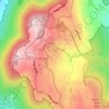
Nombre: Mapa topográfico Dandenong Ranges, altitud, relieve.
Altitud media: 456 m
Altitud mínima: 213 m
Altitud máxima: 621 m
The topography consists of a series of ridges dissected by deeply cut streams. Sheltered gullies in the south of the range are home to temperate rain forest, fern gullies and Mountain Ash forest Eucalyptus regnans, whereas the drier ridges and exposed northern slopes are covered by dry sclerophyll forest of stringybarks and box. The entire range is highly prone to bushfires, the most recent of which have been the 1983 Ash Wednesday bushfires, the 1997 Dandenong Ranges bushfires and small fires during the Black Saturday bushfires in 2009.
Otros mapas topográficos
Haga clic en un mapa para ver su topografía, su altitud y su relieve.
Mount Dandenong
Australia > Victoria > Melbourne
Mount Dandenong, Melbourne, Shire of Yarra Ranges, Victoria, 3767, Australia
Altitud media: 389 m
Mornington District
Australia > Victoria > Melbourne
Mornington District, Melbourne, Shire of Mornington Peninsula, Victoria, Australia
Altitud media: 50 m
Narre Warren North Retarding Basin (Melbourne Water)
Australia > Victoria > Melbourne
Narre Warren North Retarding Basin (Melbourne Water), Narre Warren North, Melbourne, City of Casey, Victoria, 3804, Australia
Altitud media: 76 m
Thomastown District
Australia > Victoria > Melbourne
Thomastown District, Melbourne, City of Whittlesea, Victoria, Australia
Altitud media: 158 m
Broadmeadows
Australia > Victoria > Melbourne
Broadmeadows, Melbourne, City of Hume, Victoria, 3047, Australia
Altitud media: 118 m