
Mapa topográfico Deggendorf
Mapa interactivo
Haga clic en el mapa para ver la altitud.
Acerca de este mapa
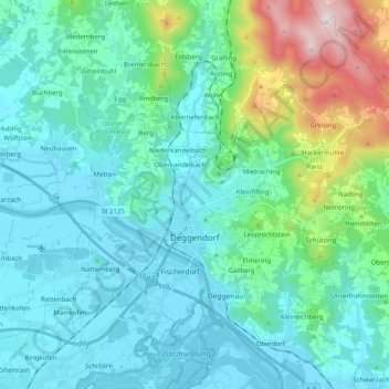
Nombre: Mapa topográfico Deggendorf, altitud, relieve.
Lugar: Deggendorf, Landkreis Deggendorf, Bavaria, 94469, Germany (48.78686 12.87356 48.90861 13.07415)
Altitud media: 449 m
Altitud mínima: 309 m
Altitud máxima: 1.101 m
Otros mapas topográficos
Haga clic en un mapa para ver su topografía, su altitud y su relieve.
Neuhausen
Germany > Bavaria > Landkreis Deggendorf
Neuhausen, Offenberg, Landkreis Deggendorf, Bavaria, 94560, Germany
Altitud media: 341 m
Otzing
Germany > Bavaria > Landkreis Deggendorf
Otzing, Oberpöring (VGem), Landkreis Deggendorf, Bavaria, 94563, Germany
Altitud media: 328 m
Schuhreith
Germany > Bavaria > Landkreis Deggendorf > Mimming
Schuhreith, Mimming, Hengersberg, Landkreis Deggendorf, Bavaria, 94491, Germany
Altitud media: 337 m
Plattling
Germany > Bavaria > Landkreis Deggendorf
Plattling, Landkreis Deggendorf, Bavaria, 94447, Germany
Altitud media: 321 m
Dobl
Germany > Bavaria > Landkreis Deggendorf
Dobl, Winzer, Landkreis Deggendorf, Bavaria, 94547, Germany
Altitud media: 378 m