
Mapa topográfico Šahy
Mapa interactivo
Haga clic en el mapa para ver la altitud.
Acerca de este mapa
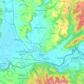
Nombre: Mapa topográfico Šahy, altitud, relieve.
Altitud media: 179 m
Altitud mínima: 119 m
Altitud máxima: 410 m
Otros mapas topográficos
Haga clic en un mapa para ver su topografía, su altitud y su relieve.
Tlmače
Slovakia > Region of Nitra > District of Levice
Tlmače, District of Levice, Region of Nitra, Western Slovakia, 935 21, Slovakia
Altitud media: 192 m
Veselá
Slovakia > Region of Nitra > District of Levice > Šarovce
Veselá, Šarovce, District of Levice, Region of Nitra, Western Slovakia, Slovakia
Altitud media: 149 m
Pastovce
Slovakia > Region of Nitra > District of Levice
Pastovce, District of Levice, Region of Nitra, Western Slovakia, Slovakia
Altitud media: 135 m