
Mapa topográfico Lake McDonald
Mapa interactivo
Haga clic en el mapa para ver la altitud.
Acerca de este mapa
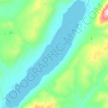
Nombre: Mapa topográfico Lake McDonald, altitud, relieve.
Lugar: Lake McDonald, Flathead County, Montana, United States (48.52745 -113.99626 48.64055 -113.86895)
Altitud media: 1.209 m
Altitud mínima: 954 m
Altitud máxima: 2.265 m
Lake McDonald is the largest lake in Glacier National Park. It is located at 48°35′N 113°55′W / 48.583°N 113.917°W / 48.583; -113.917 in Flathead County in the U.S. state of Montana. Lake McDonald is approximately 10 miles (16 km) long, and over a mile (1.6 km) wide and 472 feet (130 m) deep, filling a valley formed by a combination of erosion and glacial activity. Lake McDonald lies at an elevation of 3,153 feet (961 m) and is on the west side of the Continental Divide. Going-to-the-Sun Road parallels the lake along its southern shoreline. The surface area of the lake is 6,823 acres (27.6 km2).
Otros mapas topográficos
Haga clic en un mapa para ver su topografía, su altitud y su relieve.
Tunnel Creek
United States > Montana > Flathead County
Tunnel Creek, Flathead County, Montana, United States
Altitud media: 1.211 m
Kalispell
United States > Montana > Flathead County
Kalispell, Flathead County, Montana, United States
Altitud media: 934 m
West Glacier
United States > Montana > Flathead County > West Glacier
West Glacier, Flathead County, Montana, 59936, United States
Altitud media: 1.201 m