
Mapa topográfico Magal
Mapa interactivo
Haga clic en el mapa para ver la altitud.
Acerca de este mapa
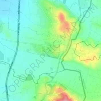
Nombre: Mapa topográfico Magal, altitud, relieve.
Altitud media: 65 m
Altitud mínima: 31 m
Altitud máxima: 150 m
Kibbutz Magal was founded in 1953 as a Nahal settlement on a hill overlooking the Samaria hills and what was then the border with Jordan. The kibbutz sits on a hill known from the War of Independence as the "86th Regiment"—on any elevation of the hill above the sea level (86 meters). The kibbutz was founded by the Tzofim battalion, but when they left, Nahal members began to settle there, which continued to reach it until the 1980s.
Otros mapas topográficos
Haga clic en un mapa para ver su topografía, su altitud y su relieve.
Regavim
Israel > Haifa District > Menashe Regional Council
Regavim, Menashe Regional Council, Hadera Subdistrict, Haifa District, Israel
Altitud media: 105 m
Barkai
Israel > Haifa District > Menashe Regional Council
Barkai, Menashe Regional Council, Hadera Subdistrict, Haifa District, Israel
Altitud media: 74 m