
Mapa topográfico Castel Gandolfo
Mapa interactivo
Haga clic en el mapa para ver la altitud.
Castel Gandolfo
The maximum elevation registered in the territory is 425 metres (1,394 ft) above sea level, at the Collegio di Propaganda Fide adjoining Villa Barberini. On the crown of the hills around the Lake Albano, the elevation is only 400 metres (1,300 ft) above sea level, at the summit of Monte Cucco, bordering Marino.
Acerca de este mapa
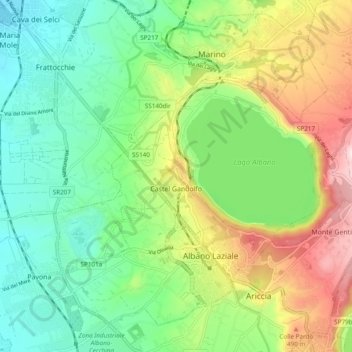
Nombre: Mapa topográfico Castel Gandolfo, altitud, relieve.
Lugar: Castel Gandolfo, Roma Capitale, 00073, Italy (41.72476 12.59258 41.76520 12.68832)
Altitud media: 306 m
Altitud mínima: 131 m
Altitud máxima: 633 m