
Haz una donación
Equípate para tu próxima aventura:
Como asociado de Amazon, este sitio gana comisiones por las compras que califican, sin ningún costo adicional para usted.
Mapa topográfico Daly City
Haga clic en el mapa para ver la altitud.
Haz una donación
Equípate para tu próxima aventura:
Como asociado de Amazon, este sitio gana comisiones por las compras que califican, sin ningún costo adicional para usted.
Daly City
Several golf courses are located within or straddle the border with San Francisco. The Olympic Club has hosted the USGA U.S. Open five times, most recently in 2012, and will host both the 2028 PGA Championship and the 2032 Ryder Cup. The private San Francisco Golf Club and Lake Merced Golf Club have part or all of their course in Daly City. The Golden Gate National Recreation Area includes the city's Thornton Beach. The topography of this area (due to the San Andreas fault) is conducive to paragliding and hang gliding.
Haz una donación
Equípate para tu próxima aventura:
Como asociado de Amazon, este sitio gana comisiones por las compras que califican, sin ningún costo adicional para usted.
Acerca de este mapa
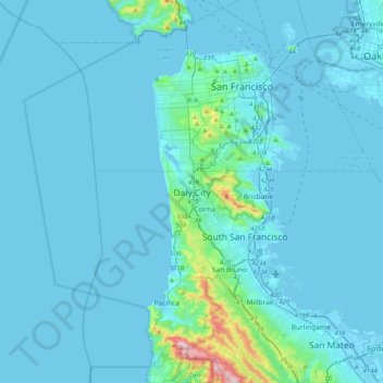
Nombre: Mapa topográfico Daly City, altitud, relieve.
Altitud media: 32 m
Altitud mínima: -6 m
Altitud máxima: 567 m
Haz una donación
Equípate para tu próxima aventura:
Como asociado de Amazon, este sitio gana comisiones por las compras que califican, sin ningún costo adicional para usted.
Otros mapas topográficos
Haga clic en un mapa para ver su topografía, su altitud y su relieve.