
Mapa topográfico Norman
Mapa interactivo
Haga clic en el mapa para ver la altitud.
Acerca de este mapa
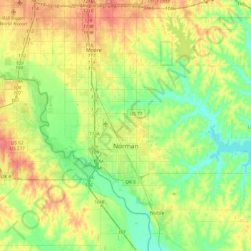
Nombre: Mapa topográfico Norman, altitud, relieve.
Lugar: Norman, Cleveland County, Oklahoma, United States (35.14532 -97.54745 35.34832 -97.17692)
Altitud media: 358 m
Altitud mínima: 317 m
Altitud máxima: 432 m
Norman and the surrounding areas are mostly flat with an elevation near 1,171 ft (357 m). The terrain in the western section of Norman is prairie, while the eastern section, including the area surrounding Lake Thunderbird, consists of some 6,000 acres (24 km2) of lakes and Cross Timbers forest. The lowest point within city limits is approximately 970 ft (296 m) above sea level (located at 35.20388N, 97.17735W). The highest point is approximately 1,245 ft (379 m) above sea level (located at 35.21266N, 97.39000W).
Otros mapas topográficos
Haga clic en un mapa para ver su topografía, su altitud y su relieve.
Tom London Dam
United States > Oklahoma > Cleveland County
Tom London Dam, Cleveland County, Oklahoma, United States
Altitud media: 324 m
Little Axe
United States > Oklahoma > Cleveland County > Norman
Little Axe, Norman, Cleveland County, Oklahoma, United States
Altitud media: 321 m
Norman
United States > Oklahoma > Cleveland County > Norman
Norman, Cleveland County, Oklahoma, 73069, United States
Altitud media: 356 m
Moore
United States > Oklahoma > Cleveland County > Moore > Moore
Moore, Cleveland County, Oklahoma, 73160, United States
Altitud media: 377 m