
Mapa topográfico Kalaburagi
Mapa interactivo
Haga clic en el mapa para ver la altitud.
Acerca de este mapa
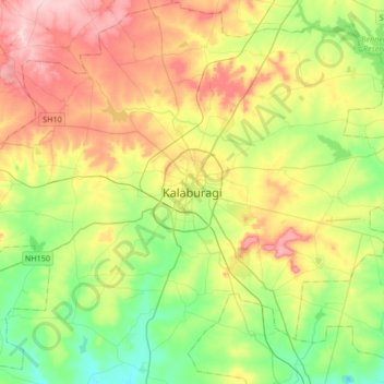
Nombre: Mapa topográfico Kalaburagi, altitud, relieve.
Altitud media: 465 m
Altitud mínima: 385 m
Altitud máxima: 582 m
The entire district is on the Deccan Plateau, and the elevation ranges from 300 to 750 m above MSL. Two main rivers, the Krishna and Bhima, flow through the district. The predominant soil type is black soil. The district has many tanks, which irrigate the land along with the river. The Upper Krishna Project is a major irrigation venture in the district of Kalaburagi. The main crops are groundnuts, rice, and pulses. Kalaburagi is the largest producer of toor dal, or pigeon peas, in Karnataka. Kalaburagi is an industrially backward district but is showing signs of growth in the cement, textile, leather and chemical industries. Kalaburagi has a university with Medical and Engineering Colleges. Central University of Karnataka (CuK) is located in Kadaganchi, Åland Taluk of Kalaburagi. The geographical area of the city is 64 square kilometres.
Otros mapas topográficos
Haga clic en un mapa para ver su topografía, su altitud y su relieve.
Melakunda
India > Karnataka > Kalaburagi taluku
Melakunda, Kalaburagi taluku, Kalaburagi District, Karnataka, India
Altitud media: 440 m
Kalaganura
India > Karnataka > Kalaburagi taluku
Kalaganura, Kalaburagi taluku, Kalaburagi District, Karnataka, 585106, India
Altitud media: 495 m