
Mapa topográfico Kalam Tehsil
Mapa interactivo
Haga clic en el mapa para ver la altitud.
Acerca de este mapa
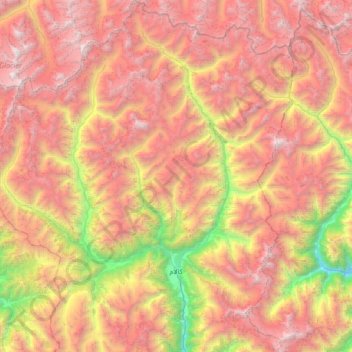
Nombre: Mapa topográfico Kalam Tehsil, altitud, relieve.
Altitud media: 3.920 m
Altitud mínima: 1.690 m
Altitud máxima: 5.971 m
At an elevation about 2,000 m (6,600 ft) above sea level, the valley itself provides a plateau that is located above the river and is used for farming. There are a number of visible mountains, also visible from Matiltan, a valley close to Kalam Valley, including Mount Falaksar at 5,918 meters (19,416 feet), and another unnamed peak at 6,096 meters (20,000 feet) high.
Otros mapas topográficos
Haga clic en un mapa para ver su topografía, su altitud y su relieve.
Behrain Tehsil
Pakistan > Khyber Pakhtunkhwa > Swat District
Behrain Tehsil, Swat District, Malakand Division, Khyber Pakhtunkhwa, Pakistan
Altitud media: 3.111 m
Swat River
Pakistan > Khyber Pakhtunkhwa > Swat District > Shini
Swat River, Shini, Swāt District, Swat District, Khyber Pakhtunkhwa, Pakistan
Altitud media: 2.018 m
Mingora
Pakistan > Khyber Pakhtunkhwa > Swat District
Mingora, Babuzai Tehsil, Swat District, Malakand Division, Khyber Pakhtunkhwa, 19130, Pakistan
Altitud media: 1.385 m
Nawagai
Pakistan > Khyber Pakhtunkhwa > Swat District > Nawagai
Nawagai, Swat District, Khyber Pakhtunkhwa, Pakistan
Altitud media: 1.058 m