
Haz una donación
Equípate para tu próxima aventura:
Como asociado de Amazon, este sitio gana comisiones por las compras que califican, sin ningún costo adicional para usted.
Mapa topográfico Mount Lyell
Haga clic en el mapa para ver la altitud.
Haz una donación
Equípate para tu próxima aventura:
Como asociado de Amazon, este sitio gana comisiones por las compras que califican, sin ningún costo adicional para usted.
Mount Lyell
The most common approach to Mount Lyell is from Tuolumne Meadows on a highly traveled section of the John Muir Trail. The round trip is approximately 25 miles (40 km) and involves 4,500 feet (1,370 m) of elevation gain when starting from the Tuolumne Wilderness Office. The hike is easy from Tuolumne Meadows, following the Tuolumne River to the head of the Lyell Canyon, and becomes moderate as it approaches Donohue Pass. Before reaching Donahue Pass, the route leaves the trail and heads south towards Mount Lyell.
Haz una donación
Equípate para tu próxima aventura:
Como asociado de Amazon, este sitio gana comisiones por las compras que califican, sin ningún costo adicional para usted.
Acerca de este mapa
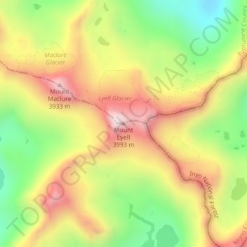
Nombre: Mapa topográfico Mount Lyell, altitud, relieve.
Lugar: Mount Lyell, Tuolumne County, California, United States (37.73937 -119.27166 37.73947 -119.27156)
Altitud media: 3.626 m
Altitud mínima: 3.283 m
Altitud máxima: 3.975 m
Haz una donación
Equípate para tu próxima aventura:
Como asociado de Amazon, este sitio gana comisiones por las compras que califican, sin ningún costo adicional para usted.
Otros mapas topográficos
Haga clic en un mapa para ver su topografía, su altitud y su relieve.
Sonora
United States > California > Tuolumne County
Sonora is located at 37°59′04″N 120°22′54″W / 37.984361°N 120.381767°W / 37.984361; -120.381767, around the intersection of California State Highways 49 and 108 The altitude is 1,825 feet (556 m). According to the United States Census Bureau, the city has a total area of 3.1 square miles…
Altitud media: 615 m
Twain Harte
United States > California > Tuolumne County
Twain Harte is situated in Tuolumne County along Highway 108 at an elevation of 3,640 feet (1,110 m).
Altitud media: 1.123 m
Haz una donación
Equípate para tu próxima aventura:
Como asociado de Amazon, este sitio gana comisiones por las compras que califican, sin ningún costo adicional para usted.
Haz una donación
Equípate para tu próxima aventura:
Como asociado de Amazon, este sitio gana comisiones por las compras que califican, sin ningún costo adicional para usted.
Haz una donación
Equípate para tu próxima aventura:
Como asociado de Amazon, este sitio gana comisiones por las compras que califican, sin ningún costo adicional para usted.
Tuolumne Meadows
United States > California > Tuolumne County > Tuolumne Meadows
Altitud media: 2.668 m
Haz una donación
Equípate para tu próxima aventura:
Como asociado de Amazon, este sitio gana comisiones por las compras que califican, sin ningún costo adicional para usted.
Sonora
United States > California > Tuolumne County
Sonora is located at 37°59′04″N 120°22′54″W / 37.984361°N 120.381767°W / 37.984361; -120.381767, around the intersection of California State Highways 49 and 108 The altitude is 1,825 feet (556 m). According to the United States Census Bureau, the city has a total area of 3.1 square miles…
Altitud media: 615 m
Columbia
United States > California > Tuolumne County
Columbia is located along State Route 49 just north of Sonora, at an altitude of 2,139 feet (652 m).
Altitud media: 672 m
Haz una donación
Equípate para tu próxima aventura:
Como asociado de Amazon, este sitio gana comisiones por las compras que califican, sin ningún costo adicional para usted.