
Mapa topográfico Granite Peak
Mapa interactivo
Haga clic en el mapa para ver la altitud.
Acerca de este mapa
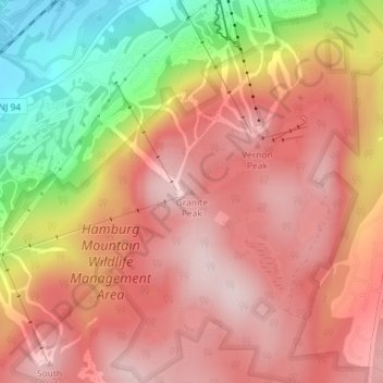
Nombre: Mapa topográfico Granite Peak, altitud, relieve.
Lugar: Granite Peak, Sussex County, New Jersey, 07472, USA (41.17623 -74.50939 41.17633 -74.50929)
Altitud media: 332 m
Altitud mínima: 123 m
Altitud máxima: 449 m
Otros mapas topográficos
Haga clic en un mapa para ver su topografía, su altitud y su relieve.
Washington Township
USA > New Jersey > Washington Township
Washington Township, Morris County, New Jersey, USA
Altitud media: 244 m
Wallington
USA > New Jersey > Wallington
Wallington, Bergen County, New Jersey, 07057, USA
Altitud media: 16 m
Parsippany-Troy Hills
USA > New Jersey > Parsippany-Troy Hills
Parsippany-Troy Hills, Morris County, New Jersey, USA
Altitud media: 113 m
Lake Vincent
USA > New Jersey > West Orange
Lake Vincent, Cecil Lane Place, West Orange, Essex County, New Jersey, 07052:07068, USA
Altitud media: 154 m
Mount Olive
USA > New Jersey > Mount Olive
Mount Olive, Morris County, New Jersey, USA
Altitud media: 280 m
Heathcote
USA > New Jersey > Heathcote
Heathcote, Middlesex County, New Jersey, 08852, USA
Altitud media: 51 m