
Haz una donación
Equípate para tu próxima aventura:
Como asociado de Amazon, este sitio gana comisiones por las compras que califican, sin ningún costo adicional para usted.
Mapa topográfico Taurus Mountains
Haga clic en el mapa para ver la altitud.
Haz una donación
Equípate para tu próxima aventura:
Como asociado de Amazon, este sitio gana comisiones por las compras que califican, sin ningún costo adicional para usted.
Taurus Mountains
The mountains have a Mediterranean climate, with dry summers and rainy winters. Temperatures vary with elevation, with warm winters on the lower coastal slopes and cold winters in the high mountains and in the interior.
Haz una donación
Equípate para tu próxima aventura:
Como asociado de Amazon, este sitio gana comisiones por las compras que califican, sin ningún costo adicional para usted.
Acerca de este mapa
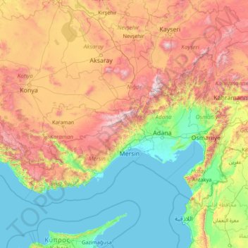
Nombre: Mapa topográfico Taurus Mountains, altitud, relieve.
Lugar: Taurus Mountains, Mediterranean Region, Turkey (36.01912 30.85785 38.39011 36.11961)
Altitud media: 828 m
Altitud mínima: -1 m
Altitud máxima: 3.578 m
Haz una donación
Equípate para tu próxima aventura:
Como asociado de Amazon, este sitio gana comisiones por las compras que califican, sin ningún costo adicional para usted.
Otros mapas topográficos
Haga clic en un mapa para ver su topografía, su altitud y su relieve.
Istanbul
Istanbul, located in northwestern Turkey, is a city that is uniquely situated across two continents, Europe and Asia, divided by the Bosphorus Strait. The city’s topography is characterized by a complex blend of hills, valleys, and coastal plains, which create a varied and scenic landscape. The European side…
Altitud media: 57 m
Ankara
Ankara has a cold semi-arid climate (Köppen climate classification: BSk). Under the Trewartha climate classification, Ankara has a temperate humid continental climate (Dc). Due to its elevation and inland location, Ankara has cold and snowy winters, and hot and dry summers. Rainfall occurs mostly during the…
Altitud media: 1.082 m
Haz una donación
Equípate para tu próxima aventura:
Como asociado de Amazon, este sitio gana comisiones por las compras que califican, sin ningún costo adicional para usted.
Antalya
While the city itself only has modest elevation changes, Antalya has high mountains in all directions to its interior. With moisture being trapped, the local climate thus has high winter rainfall, while the interior bay setting result in very hot summers for a coastal city.
Altitud media: 117 m
Haz una donación
Equípate para tu próxima aventura:
Como asociado de Amazon, este sitio gana comisiones por las compras que califican, sin ningún costo adicional para usted.
Antalya
The highest point of the Taurus mountains is Akdağ at an altitude of 3025 metres. Located to the northwest of the city centre and at a distance of 50 km (31 mi) is the Saklıkent ski and recreation centre on Beydağları. Here one can ski and then go down to the shore and into the sea during the months of…
Altitud media: 644 m
Ankara
Ankara has a cold semi-arid climate (Köppen climate classification: BSk). Under the Trewartha climate classification, Ankara has a temperate humid continental climate (Dc). Due to its elevation and inland location, Ankara has cold and snowy winters, and hot and dry summers. Rainfall occurs mostly during the…
Altitud media: 1.082 m
Haz una donación
Equípate para tu próxima aventura:
Como asociado de Amazon, este sitio gana comisiones por las compras que califican, sin ningún costo adicional para usted.
Bolvadin
Bolvadin (Ancient Greek: Πολύβοτον/Πολύβοτος and Latin: Polybotum/Polybotus) is a city of Afyonkarahisar Province in Turkey. It is the seat of Bolvadin District. Bolvadin district has a total population of 45,468 according to the 2024 census. It has an altitude of 1,016 m. The mayor is Derviş Aynaci (MHP).
Altitud media: 1.202 m
Istanbul
Istanbul, located in northwestern Turkey, is a city that is uniquely situated across two continents, Europe and Asia, divided by the Bosphorus Strait. The city’s topography is characterized by a complex blend of hills, valleys, and coastal plains, which create a varied and scenic landscape. The European side…
Altitud media: 57 m
Haz una donación
Equípate para tu próxima aventura:
Como asociado de Amazon, este sitio gana comisiones por las compras que califican, sin ningún costo adicional para usted.
Gaziantep
The plan introduced several important changes to the city's transportation network. One of the most important was the addition of a rail line to connect Gaziantep to the national rail system. Up to now, Turkish railway construction had ignored Gaziantep (partly because of its mountainous surroundings); a…
Altitud media: 880 m
Cappadocia
Cappadocia lies in central Anatolia, in the heartland of what is now Turkey. The relief consists of a high plateau over 1,000 m in altitude that is pierced by volcanic peaks, with Mount Erciyes (ancient Argaeus) near Kayseri (ancient Caesarea) being the tallest at 3,916 m. The boundaries of historical…
Altitud media: 1.167 m
Haz una donación
Equípate para tu próxima aventura:
Como asociado de Amazon, este sitio gana comisiones por las compras que califican, sin ningún costo adicional para usted.
Haz una donación
Equípate para tu próxima aventura:
Como asociado de Amazon, este sitio gana comisiones por las compras que califican, sin ningún costo adicional para usted.
Haz una donación
Equípate para tu próxima aventura:
Como asociado de Amazon, este sitio gana comisiones por las compras que califican, sin ningún costo adicional para usted.
Anatolia
Anatolia (Turkish: Anadolu), also known as Asia Minor, is a peninsula in West Asia that makes up the majority of the land area of Turkey. It is the westernmost protrusion of Asia and is geographically bounded by the Mediterranean Sea to the south, the Aegean Sea to the west, the Turkish Straits to the…
Altitud media: 518 m
Haz una donación
Equípate para tu próxima aventura:
Como asociado de Amazon, este sitio gana comisiones por las compras que califican, sin ningún costo adicional para usted.
Haz una donación
Equípate para tu próxima aventura:
Como asociado de Amazon, este sitio gana comisiones por las compras que califican, sin ningún costo adicional para usted.
Kaş
As the tenth largest district of Antalya as of 2021, Kaş is on a hill running down to the Turquoise Coast of southwestern Turkey. The district has a typical Mediterranean climate of hot, dry summers and mild, wet winters, which allows the growth of oranges, lemons and bananas. The lowland areas are also…
Altitud media: 837 m
İzmit
The city is mostly built on hill slopes because of the cramped area, while flat plains surround the gulf, near the sea. This topographic structure divided the city into two parts. The first was created on flat plains, where the city center is located. The railway and highway networks pass from this area which…
Altitud media: 194 m
Haz una donación
Equípate para tu próxima aventura:
Como asociado de Amazon, este sitio gana comisiones por las compras que califican, sin ningún costo adicional para usted.
Anatolia
Anatolia (Turkish: Anadolu), also known as Asia Minor, is a large peninsula or a region in Turkey, constituting most of its contemporary territory. Geographically, the Anatolian region is bounded by the Mediterranean Sea to the south, the Aegean Sea to the west, the Turkish Straits to the north-west, and the…
Altitud media: 952 m
Cappadocia
The area was featured in several films due to its topography. The 1983 Italian/French/Turkish film Yor, the Hunter from the Future was filmed in Cappadocia. The region was used for the 1989 science fiction film Slipstream to depict a cult of wind worshippers. In 2010 and early 2011, the film Ghost Rider:…
Altitud media: 1.167 m
Mount Ararat
Mount Ararat is a snow-capped and dormant compound volcano in the extreme east of Turkey. It consists of two major volcanic cones: Greater Ararat and Little Ararat. Greater Ararat is the highest peak in Turkey and the Armenian Highland with an elevation of 5,137 m (16,854 ft); Little Ararat's elevation is…
Altitud media: 4.582 m
Haz una donación
Equípate para tu próxima aventura:
Como asociado de Amazon, este sitio gana comisiones por las compras que califican, sin ningún costo adicional para usted.
Kaş
As the tenth largest district of Antalya as of 2021, Kaş is on a hill running down to the Turquoise Coast of southwestern Turkey. The district has a typical Mediterranean climate of hot, dry summers and mild, wet winters, which allows the growth of oranges, lemons and bananas. The lowland areas are also…
Altitud media: 837 m
Haz una donación
Equípate para tu próxima aventura:
Como asociado de Amazon, este sitio gana comisiones por las compras que califican, sin ningún costo adicional para usted.
Haz una donación
Equípate para tu próxima aventura:
Como asociado de Amazon, este sitio gana comisiones por las compras que califican, sin ningún costo adicional para usted.
Ankara
Ankara has a cold semi-arid climate (Köppen climate classification: BSk). Under the Trewartha climate classification, Ankara has a temperate humid continental climate (Dc). Due to its elevation and inland location, Ankara has cold and snowy winters, and hot and dry summers. Rainfall occurs mostly during the…
Altitud media: 1.082 m
Prince Islands
All islands contain hills, the highest being Büyükada's Aya Yorgi Hill with 203 meters of elevation.
Altitud media: 12 m
Haz una donación
Equípate para tu próxima aventura:
Como asociado de Amazon, este sitio gana comisiones por las compras que califican, sin ningún costo adicional para usted.
Haz una donación
Equípate para tu próxima aventura:
Como asociado de Amazon, este sitio gana comisiones por las compras que califican, sin ningún costo adicional para usted.
Haz una donación
Equípate para tu próxima aventura:
Como asociado de Amazon, este sitio gana comisiones por las compras que califican, sin ningún costo adicional para usted.
Haz una donación
Equípate para tu próxima aventura:
Como asociado de Amazon, este sitio gana comisiones por las compras que califican, sin ningún costo adicional para usted.
Ankara
Ankara has a cold semi-arid climate (Köppen climate classification: BSk). Under the Trewartha climate classification, Ankara has a temperate humid continental climate (Dc). Due to its elevation and inland location, Ankara has cold and snowy winters, and hot and dry summers. Rainfall occurs mostly during the…
Altitud media: 1.082 m
Sivas
The city, which lies at an elevation of 1,278 metres (4,193 ft) in the broad valley of the Kızılırmak river, is a moderately-sized trade centre and industrial city, although the economy has traditionally been based on agriculture. Rail repair shops and a thriving manufacturing industry of rugs, bricks,…
Altitud media: 1.482 m
Haz una donación
Equípate para tu próxima aventura:
Como asociado de Amazon, este sitio gana comisiones por las compras que califican, sin ningún costo adicional para usted.
Eskisehir
Eskişehir has a cold semi-arid climate (BSk) under the Köppen climate classification, and a temperate continental climate (Dc) under the Trewartha climate classification. The city features cold, snowy winters and warm, dry summers. Rainfall occurs mostly during the spring and autumn. Due to Eskişehir's high…
Altitud media: 949 m
Haz una donación
Equípate para tu próxima aventura:
Como asociado de Amazon, este sitio gana comisiones por las compras que califican, sin ningún costo adicional para usted.
Haz una donación
Equípate para tu próxima aventura:
Como asociado de Amazon, este sitio gana comisiones por las compras que califican, sin ningún costo adicional para usted.
Haz una donación
Equípate para tu próxima aventura:
Como asociado de Amazon, este sitio gana comisiones por las compras que califican, sin ningún costo adicional para usted.
Ankara
Ankara has a cold semi-arid climate (Köppen climate classification: BSk). Under the Trewartha climate classification, Ankara has a temperate humid continental climate (Dc). Due to its elevation and inland location, Ankara has cold and snowy winters, and hot and dry summers. Rainfall occurs mostly during the…
Altitud media: 1.082 m
Haz una donación
Equípate para tu próxima aventura:
Como asociado de Amazon, este sitio gana comisiones por las compras que califican, sin ningún costo adicional para usted.
Haz una donación
Equípate para tu próxima aventura:
Como asociado de Amazon, este sitio gana comisiones por las compras que califican, sin ningún costo adicional para usted.
Haz una donación
Equípate para tu próxima aventura:
Como asociado de Amazon, este sitio gana comisiones por las compras que califican, sin ningún costo adicional para usted.
Bergama
Kozak Plateau (Kozak Yaylası) is a high plain at an altitude varying between 500 and 1,000 metres (1,600 and 3,300 feet) and starting at a distance of 20 km (12 mi) from Bergama center in the northern direction. The plain is a favorite regional excursion area, famed for its hand-made textile products and pine…
Altitud media: 323 m
Haz una donación
Equípate para tu próxima aventura:
Como asociado de Amazon, este sitio gana comisiones por las compras que califican, sin ningún costo adicional para usted.