
Haz una donación
Equípate para tu próxima aventura:
Como asociado de Amazon, este sitio gana comisiones por las compras que califican, sin ningún costo adicional para usted.
Mapa topográfico Pruitt
Haga clic en el mapa para ver la altitud.
Haz una donación
Equípate para tu próxima aventura:
Como asociado de Amazon, este sitio gana comisiones por las compras que califican, sin ningún costo adicional para usted.
Acerca de este mapa
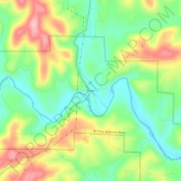
Nombre: Mapa topográfico Pruitt, altitud, relieve.
Lugar: Pruitt, Newton County, Arkansas, 72648, United States (36.04230 -93.15684 36.08230 -93.11684)
Altitud media: 300 m
Altitud mínima: 231 m
Altitud máxima: 397 m
Haz una donación
Equípate para tu próxima aventura:
Como asociado de Amazon, este sitio gana comisiones por las compras que califican, sin ningún costo adicional para usted.
Otros mapas topográficos
Haga clic en un mapa para ver su topografía, su altitud y su relieve.
Buffalo National River
United States > Arkansas > Newton County
Along the upper river, the gradient is steep and the water is fast, leveling and slowing as the river runs its course. The upper section has most of the whitewater rapids to be found along the river, and features dramatic karst topography including sink holes and caves, springs, and waterfalls, over 500-foot…
Altitud media: 444 m
Haz una donación
Equípate para tu próxima aventura:
Como asociado de Amazon, este sitio gana comisiones por las compras que califican, sin ningún costo adicional para usted.