
Mapa topográfico Bishop's Stortford
Mapa interactivo
Haga clic en el mapa para ver la altitud.
Acerca de este mapa
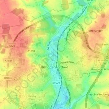
Nombre: Mapa topográfico Bishop's Stortford, altitud, relieve.
Altitud media: 83 m
Altitud mínima: 52 m
Altitud máxima: 111 m
Stortford, along with the rest of Britain, has a temperate maritime climate, with cool summers and mild winters. The nearest weather station for which averages and extremes are available is Stansted Airport, about 2+1⁄2 miles (4 kilometres) due east of Stortford's town centre. Located at an elevation of over 100 m, the weather station, and parts of Stortford in general are marginally cooler throughout the year than the Cambridgeshire area to the north or the London area to the south. Nonetheless, Stortford is still warmer than the English average.
Otros mapas topográficos
Haga clic en un mapa para ver su topografía, su altitud y su relieve.
Hertford Heath
United Kingdom > England > Hertfordshire > East Hertfordshire
Hertford Heath, East Hertfordshire, Hertfordshire, England, United Kingdom
Altitud media: 74 m
Ware
United Kingdom > England > Hertfordshire > East Hertfordshire
Ware, East Hertfordshire, Hertfordshire, England, United Kingdom
Altitud media: 55 m
Stanstead Abbotts
United Kingdom > England > Hertfordshire > East Hertfordshire
Stanstead Abbotts, East Hertfordshire, Hertfordshire, England, SG12 8HU, United Kingdom
Altitud media: 48 m