
Haz una donación
Equípate para tu próxima aventura:
Como asociado de Amazon, este sitio gana comisiones por las compras que califican, sin ningún costo adicional para usted.
Mapa topográfico Dover
Haga clic en el mapa para ver la altitud.
Haz una donación
Equípate para tu próxima aventura:
Como asociado de Amazon, este sitio gana comisiones por las compras que califican, sin ningún costo adicional para usted.
Dover
The mild hills historically supported oak-hickory forest or oak-hickory-pine forest. Elevation changes and soil types make the Arkansas Valley Hills largely unsuitable for row agriculture. Instead, forest has been cleared for pastureland, poultry farming or ranching. Logging remains an important land use where elevation or soil makes livestock farming unsuitable. Many of the smaller streams and watercourses are completely dry in summer.
Haz una donación
Equípate para tu próxima aventura:
Como asociado de Amazon, este sitio gana comisiones por las compras que califican, sin ningún costo adicional para usted.
Acerca de este mapa
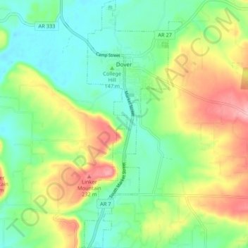
Nombre: Mapa topográfico Dover, altitud, relieve.
Lugar: Dover, Pope County, Arkansas, 72837, United States (35.35115 -93.12742 35.41773 -93.09518)
Altitud media: 164 m
Altitud mínima: 113 m
Altitud máxima: 252 m
Haz una donación
Equípate para tu próxima aventura:
Como asociado de Amazon, este sitio gana comisiones por las compras que califican, sin ningún costo adicional para usted.
Otros mapas topográficos
Haga clic en un mapa para ver su topografía, su altitud y su relieve.
Dover
United States > Arkansas > Pope County > Dover > Dover
The mild hills historically supported oak-hickory forest or oak-hickory-pine forest. Elevation changes and soil types make the Arkansas Valley Hills largely unsuitable for row agriculture. Instead, forest has been cleared for pastureland, poultry farming or ranching. Logging remains an important land use where…
Altitud media: 150 m
Haz una donación
Equípate para tu próxima aventura:
Como asociado de Amazon, este sitio gana comisiones por las compras que califican, sin ningún costo adicional para usted.