
Haz una donación
Equípate para tu próxima aventura:
Como asociado de Amazon, este sitio gana comisiones por las compras que califican, sin ningún costo adicional para usted.
Mapa topográfico Winlock
Haga clic en el mapa para ver la altitud.
Haz una donación
Equípate para tu próxima aventura:
Como asociado de Amazon, este sitio gana comisiones por las compras que califican, sin ningún costo adicional para usted.
Winlock
The eastern edge of the Willapa Hills lie to the west. To the east are relatively flat prairies. A notable landmark about four miles west of town is Sam Henry Mountain, elevation 1,492 feet (455 m), named for an early section superintendent of the Northern Pacific Railroad. Mt. St. Helens, about forty miles (64.4 km) to the east can be seen from viewpoints around the area. In May 1980, Winlock was covered with about one inch (2.54 cm) of volcanic ash from the second major eruption of this peak one week after the cataclysmic eruption of May 18.
Haz una donación
Equípate para tu próxima aventura:
Como asociado de Amazon, este sitio gana comisiones por las compras que califican, sin ningún costo adicional para usted.
Acerca de este mapa
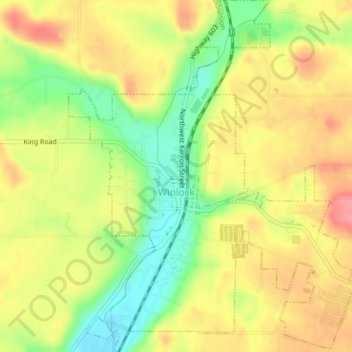
Nombre: Mapa topográfico Winlock, altitud, relieve.
Lugar: Winlock, Lewis County, Washington, United States (46.48013 -122.95086 46.50712 -122.91892)
Altitud media: 124 m
Altitud mínima: 78 m
Altitud máxima: 162 m
Haz una donación
Equípate para tu próxima aventura:
Como asociado de Amazon, este sitio gana comisiones por las compras que califican, sin ningún costo adicional para usted.
Otros mapas topográficos
Haga clic en un mapa para ver su topografía, su altitud y su relieve.
Haz una donación
Equípate para tu próxima aventura:
Como asociado de Amazon, este sitio gana comisiones por las compras que califican, sin ningún costo adicional para usted.
Haz una donación
Equípate para tu próxima aventura:
Como asociado de Amazon, este sitio gana comisiones por las compras que califican, sin ningún costo adicional para usted.
Haz una donación
Equípate para tu próxima aventura:
Como asociado de Amazon, este sitio gana comisiones por las compras que califican, sin ningún costo adicional para usted.