
Haz una donación
Equípate para tu próxima aventura:
Como asociado de Amazon, este sitio gana comisiones por las compras que califican, sin ningún costo adicional para usted.
Mapa topográfico Vliet
Haga clic en el mapa para ver la altitud.
Haz una donación
Equípate para tu próxima aventura:
Como asociado de Amazon, este sitio gana comisiones por las compras que califican, sin ningún costo adicional para usted.
Acerca de este mapa
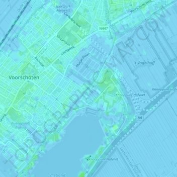
Nombre: Mapa topográfico Vliet, altitud, relieve.
Altitud media: 1 m
Altitud mínima: -4 m
Altitud máxima: 6 m
Haz una donación
Equípate para tu próxima aventura:
Como asociado de Amazon, este sitio gana comisiones por las compras que califican, sin ningún costo adicional para usted.
Otros mapas topográficos
Haga clic en un mapa para ver su topografía, su altitud y su relieve.
Wilsveen
Nederland > Zuid-Holland > Leidschendam
Wilsveen wordt omgeven door drie polders: Potteveen ten noordwesten van de weg; de Grote Drooggemaakte Polder ten noordoosten van Wilsveen, en de Nieuwe Driemanspolder ten zuiden van de weg. Op de grens van de twee eerstgenoemde polders ligt langs de zogenaamde Molenvaart een molendriegang. Deze drie molens…
Altitud media: -3 m