Geolocalizar
👉 Easily get elevation data in JSON, GeoTIFF and KML formats using Elevation API
Gracias por apoyar a este sitio ❤️
Haz una donación

Equípate para tu próxima aventura:

Como asociado de Amazon, este sitio gana comisiones por las compras que califican, sin ningún costo adicional para usted.

Mapa topográfico Keycol Hill

Haga clic en el mapa para ver la altitud.

Acerca de este mapa

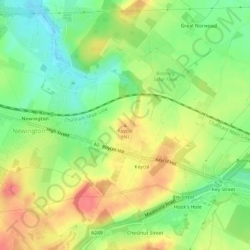
Nombre: Mapa topográfico Keycol Hill, altitud, relieve.

Lugar: Keycol Hill, Borough of Swale, Kent, England, ME9 7JF, United Kingdom (51.35209 0.68230 51.35219 0.68240)

Altitud media: 40 m

Altitud mínima: 7 m

Altitud máxima: 76 m

Otros mapas topográficos

Haga clic en un mapa para ver su topografía, su altitud y su relieve.

Selling

United Kingdom > England > Kent > Borough of Swale

Altitud media: 64 m

Bobbing

United Kingdom > England > Kent > Borough of Swale

Altitud media: 32 m

Iwade

United Kingdom > England > Kent > Borough of Swale

Altitud media: 6 m

Borden

United Kingdom > England > Kent > Borough of Swale > Borden

Altitud media: 64 m

Oare

United Kingdom > England > Kent > Borough of Swale > Oare

Altitud media: 4 m

Tonge

United Kingdom > England > Kent > Borough of Swale > Bapchild

Altitud media: 23 m

Bredgar

United Kingdom > England > Kent > Borough of Swale

Altitud media: 100 m

Equípate para tu próxima aventura:

🧤Guantes Impermeables - Manos secas en condiciones de lluvia y frío
🧱Fundas impermeables móvil - Protección del smartphone
🧼Jabón Biodegradable - Higiene respetuosa con el medio ambiente
🔦Farolillos de Camping - Iluminación ambiental para tu zona de acampada
🔦Linternas Frontales Potentes - Iluminación manos libres para rutas nocturnas o cuevas

Como asociado de Amazon, este sitio gana comisiones por las compras que califican, sin ningún costo adicional para usted.