
Haz una donación
Equípate para tu próxima aventura:
Como asociado de Amazon, este sitio gana comisiones por las compras que califican, sin ningún costo adicional para usted.
Mapa topográfico Esher
Haga clic en el mapa para ver la altitud.
Haz una donación
Equípate para tu próxima aventura:
Como asociado de Amazon, este sitio gana comisiones por las compras que califican, sin ningún costo adicional para usted.
Esher
Esher is an outlying suburb of London near the London-Surrey Border, and with Esher Commons at its southern end, the town marks one limit of the Greater London Built-Up Area. Esher has a linear commercial high street and is otherwise suburban in density, with varying elevations, few high rise buildings and very short sections of dual carriageway within the ward itself. Esher covers a large area, between 13 and 15.4 miles southwest of Charing Cross.[n 1] In the south it is bounded by the A3 Portsmouth Road which is of urban motorway standard and buffered by the Esher Commons.
Haz una donación
Equípate para tu próxima aventura:
Como asociado de Amazon, este sitio gana comisiones por las compras que califican, sin ningún costo adicional para usted.
Acerca de este mapa
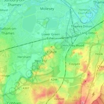
Nombre: Mapa topográfico Esher, altitud, relieve.
Lugar: Esher, Elmbridge, Surrey, England, KT10 9QU, United Kingdom (51.32939 -0.40542 51.40939 -0.32542)
Altitud media: 27 m
Altitud mínima: -2 m
Altitud máxima: 88 m
Haz una donación
Equípate para tu próxima aventura:
Como asociado de Amazon, este sitio gana comisiones por las compras que califican, sin ningún costo adicional para usted.
Otros mapas topográficos
Haga clic en un mapa para ver su topografía, su altitud y su relieve.