
Mapa topográfico Limeira do Oeste
Mapa interactivo
Haga clic en el mapa para ver la altitud.
Acerca de este mapa
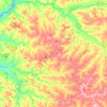
Nombre: Mapa topográfico Limeira do Oeste, altitud, relieve.
Altitud media: 428 m
Altitud mínima: 322 m
Altitud máxima: 542 m
Limeira do Oeste belongs to the statistical micro-region of Frutal. It is located in the extreme west of the rich region of western Minas Gerais known as the Triângulo Mineiro at an elevation of 428 meters. Neighboring municipalities are: