
Haz una donación
Equípate para tu próxima aventura:
Como asociado de Amazon, este sitio gana comisiones por las compras que califican, sin ningún costo adicional para usted.
Mapa topográfico Lüsberg
Haga clic en el mapa para ver la altitud.
Haz una donación
Equípate para tu próxima aventura:
Como asociado de Amazon, este sitio gana comisiones por las compras que califican, sin ningún costo adicional para usted.
Acerca de este mapa
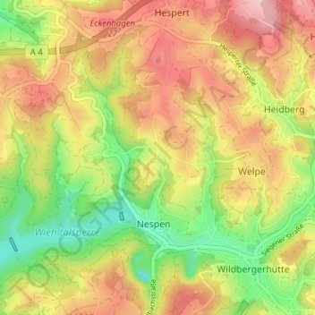
Nombre: Mapa topográfico Lüsberg, altitud, relieve.
Altitud media: 369 m
Altitud mínima: 273 m
Altitud máxima: 460 m
Haz una donación
Equípate para tu próxima aventura:
Como asociado de Amazon, este sitio gana comisiones por las compras que califican, sin ningún costo adicional para usted.
Otros mapas topográficos
Haga clic en un mapa para ver su topografía, su altitud y su relieve.
Wiehltalsperre
Deutschland > Nordrhein-Westfalen > Oberbergischer Kreis > Reichshof > Nespen
Der Staudamm bei Ufersmühle staut das Wasser der Wiehl bis auf eine Höhe von 292,5 m ü. NN (Normalstau) bzw. 293,11 m ü. NN (Höchststau). Es handelt sich um einen Steinschüttdamm mit innen liegender Asphaltbetondichtung. Mit dem Talsperrenwasser aus der Wiehltalsperre und aus der Genkeltalsperre stellt…
Altitud media: 362 m